You are here: Home > Network List > AE - Arizona Broadband Seismic Network Stations List
> Station 319A Douglas, AZ, USA > Earthquake Result Viewer
319A Douglas, AZ, USA - Earthquake Result Viewer
| Earthquake location: |
Panama-Colombia Border Region |
| Earthquake latitude/longitude: |
8.2/-77.3 |
| Earthquake time(UTC): |
2015/07/29 (210) 00:10:24 GMT |
| Earthquake Depth: |
10 km |
| Earthquake Magnitude: |
5.9 MWP, 6.1 MI |
| Earthquake Catalog/Contributor: |
NEIC PDE/NEIC COMCAT |
|
| Network: |
AE Arizona Broadband Seismic Network |
| Station: |
319A Douglas, AZ, USA |
| Lat/Lon: |
31.38 N/109.28 W |
| Elevation: |
1187 m |
|
| Distance: |
37.6 deg |
| Az: |
312.116 deg |
| Baz: |
120.858 deg |
| Ray Param: |
0.07602332 |
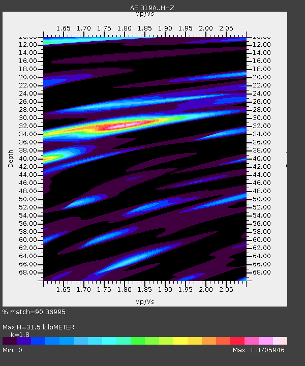
| Estimated Moho Depth: |
31.5 km |
| Estimated Crust Vp/Vs: |
1.80 |
| Assumed Crust Vp: |
6.182 km/s |
| Estimated Crust Vs: |
3.435 km/s |
| Estimated Crust Poisson's Ratio: |
0.28 |
|
| Radial Match: |
90.36995 % |
| Radial Bump: |
400 |
| Transverse Match: |
56.889847 % |
| Transverse Bump: |
400 |
| SOD ConfigId: |
7422571 |
| Insert Time: |
2019-04-20 01:28:04.604 +0000 |
| GWidth: |
2.5 |
| Max Bumps: |
400 |
| Tol: |
0.001 |
|

Signal To Noise
| Channel | StoN | STA | LTA |
| AE:319A: :HHZ:20150729T00:17:07.419999Z | 10.8757515 | 1.1392187E-6 | 1.047485E-7 |
| AE:319A: :HHN:20150729T00:17:07.419999Z | 4.9073052 | 4.6349308E-7 | 9.444961E-8 |
| AE:319A: :HHE:20150729T00:17:07.419999Z | 5.3828936 | 6.823632E-7 | 1.2676512E-7 |
| Arrivals |
| Ps | 4.4 SECOND |
| PpPs | 13 SECOND |
| PsPs/PpSs | 18 SECOND |


