You are here: Home > Network List > UO - University of Oregon Regional Network Stations List
> Station SLPT Klamath Falls, OR, USA > Earthquake Result Viewer
SLPT Klamath Falls, OR, USA - Earthquake Result Viewer
| Earthquake location: |
Near West Coast Of Honshu, Japan |
| Earthquake latitude/longitude: |
37.5/137.2 |
| Earthquake time(UTC): |
2024/01/01 (001) 07:10:10 GMT |
| Earthquake Depth: |
0.0 km |
| Earthquake Magnitude: |
7.4 Mi |
| Earthquake Catalog/Contributor: |
NEIC PDE/pt |
|
| Network: |
UO University of Oregon Regional Network |
| Station: |
SLPT Klamath Falls, OR, USA |
| Lat/Lon: |
42.41 N/121.67 W |
| Elevation: |
2208 m |
|
| Distance: |
72.9 deg |
| Az: |
49.48 deg |
| Baz: |
305.28 deg |
| Ray Param: |
0.05337012 |
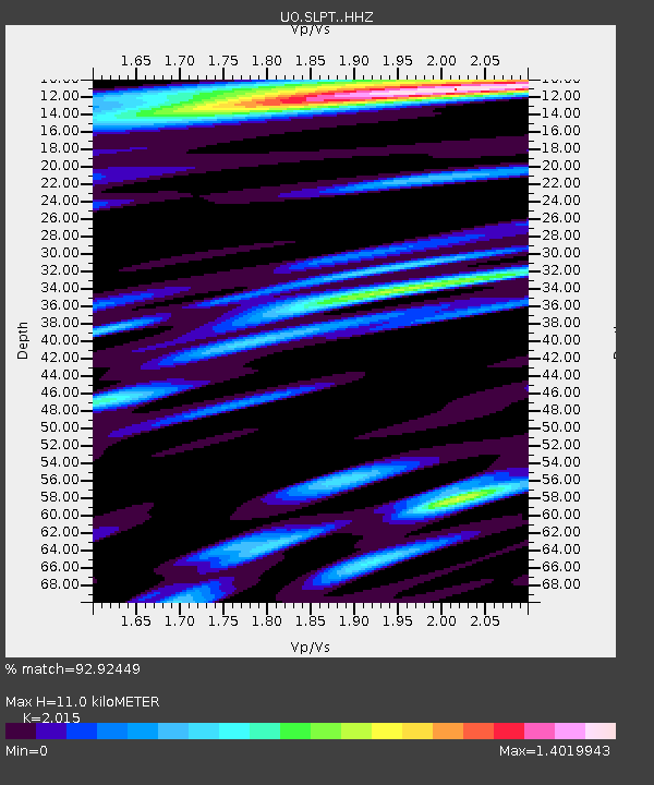
| Estimated Moho Depth: |
11.0 km |
| Estimated Crust Vp/Vs: |
2.02 |
| Assumed Crust Vp: |
6.597 km/s |
| Estimated Crust Vs: |
3.274 km/s |
| Estimated Crust Poisson's Ratio: |
0.34 |
|
| Radial Match: |
92.92449 % |
| Radial Bump: |
400 |
| Transverse Match: |
87.43135 % |
| Transverse Bump: |
400 |
| SOD ConfigId: |
33437571 |
| Insert Time: |
2024-01-15 08:11:13.779 +0000 |
| GWidth: |
2.5 |
| Max Bumps: |
400 |
| Tol: |
0.001 |
|

Signal To Noise
| Channel | StoN | STA | LTA |
| UO:SLPT: :HHZ:20240101T07:21:09.690002Z | 9.444254 | 2.0823504E-6 | 2.2048862E-7 |
| UO:SLPT: :HHN:20240101T07:21:09.690002Z | 1.8423226 | 7.1770523E-7 | 3.8956543E-7 |
| UO:SLPT: :HHE:20240101T07:21:09.690002Z | 1.1943827 | 9.291673E-7 | 7.779478E-7 |
| Arrivals |
| Ps | 1.7 SECOND |
| PpPs | 4.9 SECOND |
| PsPs/PpSs | 6.6 SECOND |


