You are here: Home > Network List > UO - University of Oregon Regional Network Stations List
> Station SLPT Klamath Falls, OR, USA > Earthquake Result Viewer
SLPT Klamath Falls, OR, USA - Earthquake Result Viewer
| Earthquake location: |
Tonga Islands |
| Earthquake latitude/longitude: |
-19.4/-174.9 |
| Earthquake time(UTC): |
2024/05/26 (147) 20:47:09 GMT |
| Earthquake Depth: |
112 km |
| Earthquake Magnitude: |
6.6 mww |
| Earthquake Catalog/Contributor: |
NEIC PDE/us |
|
| Network: |
UO University of Oregon Regional Network |
| Station: |
SLPT Klamath Falls, OR, USA |
| Lat/Lon: |
42.41 N/121.67 W |
| Elevation: |
2208 m |
|
| Distance: |
78.6 deg |
| Az: |
37.223 deg |
| Baz: |
230.451 deg |
| Ray Param: |
0.049256597 |
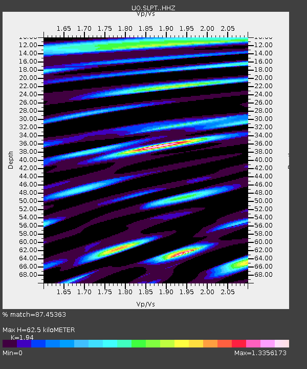
| Estimated Moho Depth: |
62.5 km |
| Estimated Crust Vp/Vs: |
1.94 |
| Assumed Crust Vp: |
6.597 km/s |
| Estimated Crust Vs: |
3.401 km/s |
| Estimated Crust Poisson's Ratio: |
0.32 |
|
| Radial Match: |
87.45363 % |
| Radial Bump: |
400 |
| Transverse Match: |
76.13643 % |
| Transverse Bump: |
400 |
| SOD ConfigId: |
35001331 |
| Insert Time: |
2024-06-09 21:24:43.222 +0000 |
| GWidth: |
2.5 |
| Max Bumps: |
400 |
| Tol: |
0.001 |
|

Signal To Noise
| Channel | StoN | STA | LTA |
| UO:SLPT: :HHZ:20240526T20:58:27.730008Z | 24.336922 | 3.4682098E-6 | 1.4250814E-7 |
| UO:SLPT: :HHN:20240526T20:58:27.730008Z | 4.757789 | 7.117898E-7 | 1.4960516E-7 |
| UO:SLPT: :HHE:20240526T20:58:27.730008Z | 2.579431 | 7.2944914E-7 | 2.827946E-7 |
| Arrivals |
| Ps | 9.2 SECOND |
| PpPs | 27 SECOND |
| PsPs/PpSs | 36 SECOND |


