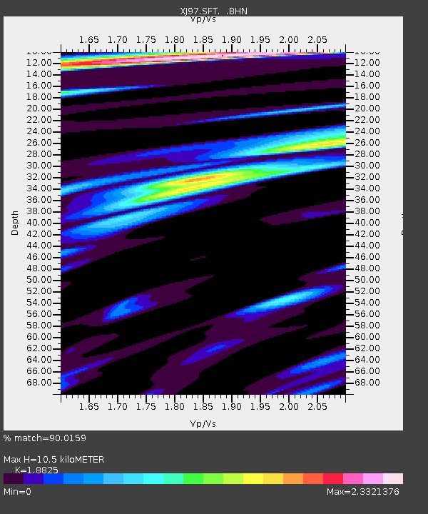
SFT Sage Flat - Earthquake Result Viewer

Earthquake location: Andreanof Islands, Aleutian Is.
Earthquake latitude/longitude: 51.3/-179.3
Earthquake time(UTC): 1997/06/17 (168) 21:03:40 GMT
Earthquake Depth: 33 km
Earthquake Magnitude: 6.4 MB, 6.3 MS, 6.4 UNKNOWN, 6.6 ML
Earthquake Catalog/Contributor: WHDF/NEIC
Network: XJ Sierran Paradox
Station: SFT Sage Flat
Lat/Lon: 36.23 N/118.06 W
Elevation: 1753 m
Distance: 45.4 deg
Az: 84.655 deg
Baz: 309.439 deg
Ray Param: 0.07123203
Estimated Moho Depth: 10.5 km
Estimated Crust Vp/Vs: 1.88
Assumed Crust Vp: 6.291 km/s
Estimated Crust Vs: 3.342 km/s
Estimated Crust Poisson's Ratio: 0.30
Radial Match: 90.0159 %
Radial Bump: 400
Transverse Match: 78.311386 %
Transverse Bump: 400
SOD ConfigId: 6273
Insert Time: 2010-03-09 20:15:26.190 +0000
GWidth: 2.5
Max Bumps: 400
Tol: 0.001

Signal To Noise

ChannelStoNSTALTA
XJ:SFT: :BHN:19970617T21:11:25.10799Z5.84526066.4409755E-71.10191415E-7
XJ:SFT: :BHE:19970617T21:11:25.10799Z3.5084884.9566256E-71.4127527E-7
XJ:SFT: :BHZ:19970617T21:11:25.10799Z15.2326411.7948305E-61.1782792E-7
Arrivals
Ps1.6 SECOND
PpPs4.5 SECOND
PsPs/PpSs6.1 SECOND