You are here: Home > Network List > XJ97 - Sierran Paradox Stations List
> Station SFT Sage Flat > Earthquake Result Viewer
SFT Sage Flat - Earthquake Result Viewer
| Earthquake location: |
Colombia |
| Earthquake latitude/longitude: |
3.8/-75.7 |
| Earthquake time(UTC): |
1997/09/02 (245) 12:13:22 GMT |
| Earthquake Depth: |
199 km |
| Earthquake Magnitude: |
6.5 MB, 6.8 UNKNOWN, 6.4 ME |
| Earthquake Catalog/Contributor: |
WHDF/NEIC |
|
| Network: |
XJ Sierran Paradox |
| Station: |
SFT Sage Flat |
| Lat/Lon: |
36.23 N/118.06 W |
| Elevation: |
1753 m |
|
| Distance: |
50.5 deg |
| Az: |
315.156 deg |
| Baz: |
119.515 deg |
| Ray Param: |
0.06728924 |
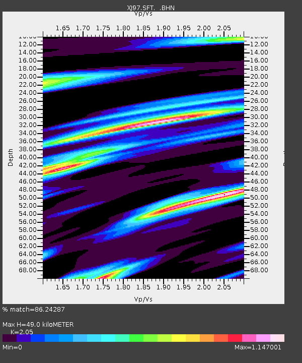
| Estimated Moho Depth: |
49.0 km |
| Estimated Crust Vp/Vs: |
2.05 |
| Assumed Crust Vp: |
6.291 km/s |
| Estimated Crust Vs: |
3.069 km/s |
| Estimated Crust Poisson's Ratio: |
0.34 |
|
| Radial Match: |
86.24287 % |
| Radial Bump: |
400 |
| Transverse Match: |
73.14534 % |
| Transverse Bump: |
400 |
| SOD ConfigId: |
6273 |
| Insert Time: |
2010-03-09 20:15:30.129 +0000 |
| GWidth: |
2.5 |
| Max Bumps: |
400 |
| Tol: |
0.001 |
|

Signal To Noise
| Channel | StoN | STA | LTA |
| XJ:SFT: :BHN:19970902T12:21:30.181006Z | 1.7158256 | 3.0203066E-7 | 1.7602643E-7 |
| XJ:SFT: :BHE:19970902T12:21:30.181006Z | 3.1559546 | 2.1706748E-7 | 6.8780295E-8 |
| XJ:SFT: :BHZ:19970902T12:21:30.181006Z | 7.7902474 | 8.2250455E-7 | 1.0558131E-7 |
| Arrivals |
| Ps | 8.6 SECOND |
| PpPs | 23 SECOND |
| PsPs/PpSs | 31 SECOND |


