You are here: Home > Network List > XJ97 - Sierran Paradox Stations List
> Station SFT Sage Flat > Earthquake Result Viewer
SFT Sage Flat - Earthquake Result Viewer
| Earthquake location: |
South Of Fiji Islands |
| Earthquake latitude/longitude: |
-26.6/178.3 |
| Earthquake time(UTC): |
1997/09/04 (247) 04:23:37 GMT |
| Earthquake Depth: |
625 km |
| Earthquake Magnitude: |
6.3 MB, 6.8 UNKNOWN, 6.5 ME |
| Earthquake Catalog/Contributor: |
WHDF/NEIC |
|
| Network: |
XJ Sierran Paradox |
| Station: |
SFT Sage Flat |
| Lat/Lon: |
36.23 N/118.06 W |
| Elevation: |
1753 m |
|
| Distance: |
86.6 deg |
| Az: |
46.513 deg |
| Baz: |
233.481 deg |
| Ray Param: |
0.0421363 |
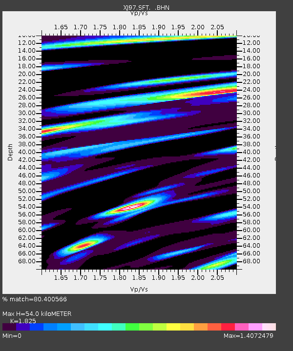
| Estimated Moho Depth: |
54.0 km |
| Estimated Crust Vp/Vs: |
1.83 |
| Assumed Crust Vp: |
6.291 km/s |
| Estimated Crust Vs: |
3.447 km/s |
| Estimated Crust Poisson's Ratio: |
0.29 |
|
| Radial Match: |
80.400566 % |
| Radial Bump: |
400 |
| Transverse Match: |
72.3374 % |
| Transverse Bump: |
400 |
| SOD ConfigId: |
6273 |
| Insert Time: |
2010-03-09 20:15:34.989 +0000 |
| GWidth: |
2.5 |
| Max Bumps: |
400 |
| Tol: |
0.001 |
|

Signal To Noise
| Channel | StoN | STA | LTA |
| XJ:SFT: :BHN:19970904T04:34:44.140015Z | 2.132179 | 2.655305E-7 | 1.2453481E-7 |
| XJ:SFT: :BHE:19970904T04:34:44.140015Z | 2.9582949 | 2.4167588E-7 | 8.169432E-8 |
| XJ:SFT: :BHZ:19970904T04:34:44.140015Z | 10.225144 | 9.344173E-7 | 9.138426E-8 |
| Arrivals |
| Ps | 7.2 SECOND |
| PpPs | 24 SECOND |
| PsPs/PpSs | 31 SECOND |


