You are here: Home > Network List > UW - Pacific Northwest Regional Seismic Network Stations List
> Station LCCR Clarks, OR, USA > Earthquake Result Viewer
LCCR Clarks, OR, USA - Earthquake Result Viewer
| Earthquake location: |
Shikoku, Japan |
| Earthquake latitude/longitude: |
33.2/132.4 |
| Earthquake time(UTC): |
2024/04/17 (108) 14:14:45 GMT |
| Earthquake Depth: |
26 km |
| Earthquake Magnitude: |
6.3 mww |
| Earthquake Catalog/Contributor: |
NEIC PDE/us |
|
| Network: |
UW Pacific Northwest Regional Seismic Network |
| Station: |
LCCR Clarks, OR, USA |
| Lat/Lon: |
45.21 N/122.48 W |
| Elevation: |
271 m |
|
| Distance: |
76.7 deg |
| Az: |
44.528 deg |
| Baz: |
303.689 deg |
| Ray Param: |
0.050800536 |
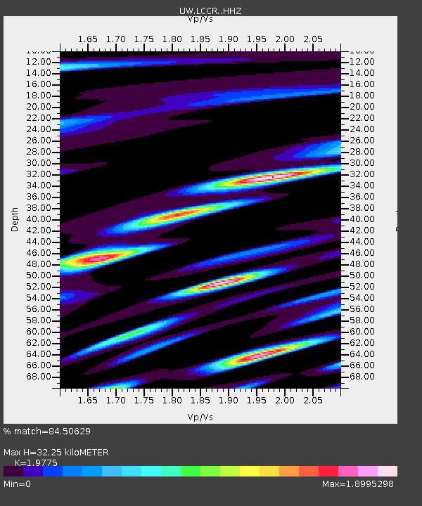
| Estimated Moho Depth: |
32.25 km |
| Estimated Crust Vp/Vs: |
1.98 |
| Assumed Crust Vp: |
6.566 km/s |
| Estimated Crust Vs: |
3.32 km/s |
| Estimated Crust Poisson's Ratio: |
0.33 |
|
| Radial Match: |
84.50629 % |
| Radial Bump: |
400 |
| Transverse Match: |
67.28252 % |
| Transverse Bump: |
400 |
| SOD ConfigId: |
34243671 |
| Insert Time: |
2024-05-09 02:12:05.330 +0000 |
| GWidth: |
2.5 |
| Max Bumps: |
400 |
| Tol: |
0.001 |
|

Signal To Noise
| Channel | StoN | STA | LTA |
| UW:LCCR: :HHZ:20240417T14:26:03.090009Z | 9.661918 | 2.3977568E-6 | 2.4816572E-7 |
| UW:LCCR: :HHN:20240417T14:26:03.090009Z | 2.411169 | 6.42585E-7 | 2.6650352E-7 |
| UW:LCCR: :HHE:20240417T14:26:03.090009Z | 2.5258389 | 8.282491E-7 | 3.2791047E-7 |
| Arrivals |
| Ps | 4.9 SECOND |
| PpPs | 14 SECOND |
| PsPs/PpSs | 19 SECOND |


