You are here: Home > Network List > UW - Pacific Northwest Regional Seismic Network Stations List
> Station LCCR Clarks, OR, USA > Earthquake Result Viewer
LCCR Clarks, OR, USA - Earthquake Result Viewer
| Earthquake location: |
Near Coast Of Chiapas, Mexico |
| Earthquake latitude/longitude: |
14.5/-92.4 |
| Earthquake time(UTC): |
2024/05/12 (133) 11:39:14 GMT |
| Earthquake Depth: |
75 km |
| Earthquake Magnitude: |
6.4 mww |
| Earthquake Catalog/Contributor: |
NEIC PDE/us |
|
| Network: |
UW Pacific Northwest Regional Seismic Network |
| Station: |
LCCR Clarks, OR, USA |
| Lat/Lon: |
45.21 N/122.48 W |
| Elevation: |
271 m |
|
| Distance: |
39.8 deg |
| Az: |
326.383 deg |
| Baz: |
130.652 deg |
| Ray Param: |
0.07451532 |
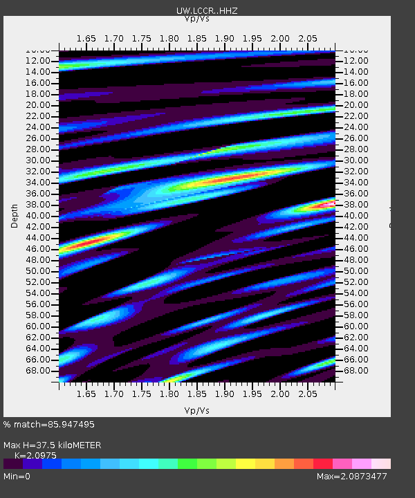
| Estimated Moho Depth: |
37.5 km |
| Estimated Crust Vp/Vs: |
2.10 |
| Assumed Crust Vp: |
6.566 km/s |
| Estimated Crust Vs: |
3.13 km/s |
| Estimated Crust Poisson's Ratio: |
0.35 |
|
| Radial Match: |
85.947495 % |
| Radial Bump: |
400 |
| Transverse Match: |
80.883125 % |
| Transverse Bump: |
400 |
| SOD ConfigId: |
34924831 |
| Insert Time: |
2024-05-28 19:57:24.840 +0000 |
| GWidth: |
2.5 |
| Max Bumps: |
400 |
| Tol: |
0.001 |
|

Signal To Noise
| Channel | StoN | STA | LTA |
| UW:LCCR: :HHZ:20240512T11:46:09.810004Z | 16.636776 | 2.392252E-6 | 1.43793E-7 |
| UW:LCCR: :HHN:20240512T11:46:09.810004Z | 3.8809607 | 1.0081769E-6 | 2.5977508E-7 |
| UW:LCCR: :HHE:20240512T11:46:09.810004Z | 3.2709146 | 1.1386442E-6 | 3.4811185E-7 |
| Arrivals |
| Ps | 6.7 SECOND |
| PpPs | 17 SECOND |
| PsPs/PpSs | 23 SECOND |


