You are here: Home > Network List > UW - Pacific Northwest Regional Seismic Network Stations List
> Station LCCR Clarks, OR, USA > Earthquake Result Viewer
LCCR Clarks, OR, USA - Earthquake Result Viewer
| Earthquake location: |
Fox Islands, Aleutian Islands |
| Earthquake latitude/longitude: |
52.2/-170.9 |
| Earthquake time(UTC): |
2024/05/19 (140) 09:35:24 GMT |
| Earthquake Depth: |
28 km |
| Earthquake Magnitude: |
6.0 mww |
| Earthquake Catalog/Contributor: |
NEIC PDE/us |
|
| Network: |
UW Pacific Northwest Regional Seismic Network |
| Station: |
LCCR Clarks, OR, USA |
| Lat/Lon: |
45.21 N/122.48 W |
| Elevation: |
271 m |
|
| Distance: |
32.2 deg |
| Az: |
82.892 deg |
| Baz: |
300.148 deg |
| Ray Param: |
0.07873739 |
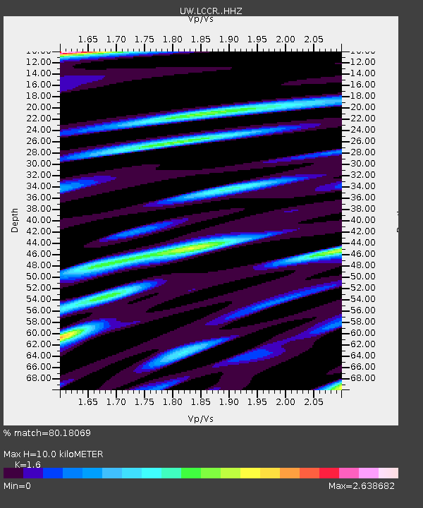
| Estimated Moho Depth: |
10.0 km |
| Estimated Crust Vp/Vs: |
1.60 |
| Assumed Crust Vp: |
6.566 km/s |
| Estimated Crust Vs: |
4.104 km/s |
| Estimated Crust Poisson's Ratio: |
0.18 |
|
| Radial Match: |
80.18069 % |
| Radial Bump: |
400 |
| Transverse Match: |
65.20929 % |
| Transverse Bump: |
400 |
| SOD ConfigId: |
35001331 |
| Insert Time: |
2024-06-02 10:14:34.716 +0000 |
| GWidth: |
2.5 |
| Max Bumps: |
400 |
| Tol: |
0.001 |
|

Signal To Noise
| Channel | StoN | STA | LTA |
| UW:LCCR: :HHZ:20240519T09:41:19.969997Z | 4.341796 | 5.9043833E-7 | 1.3598941E-7 |
| UW:LCCR: :HHN:20240519T09:41:19.969997Z | 1.2003664 | 2.7463926E-7 | 2.287962E-7 |
| UW:LCCR: :HHE:20240519T09:41:19.969997Z | 1.859041 | 5.102448E-7 | 2.7446666E-7 |
| Arrivals |
| Ps | 1.0 SECOND |
| PpPs | 3.6 SECOND |
| PsPs/PpSs | 4.6 SECOND |


