You are here: Home > Network List > TA - USArray Transportable Network (new EarthScope stations) Stations List
> Station 243A Waterproof, LA, USA > Earthquake Result Viewer
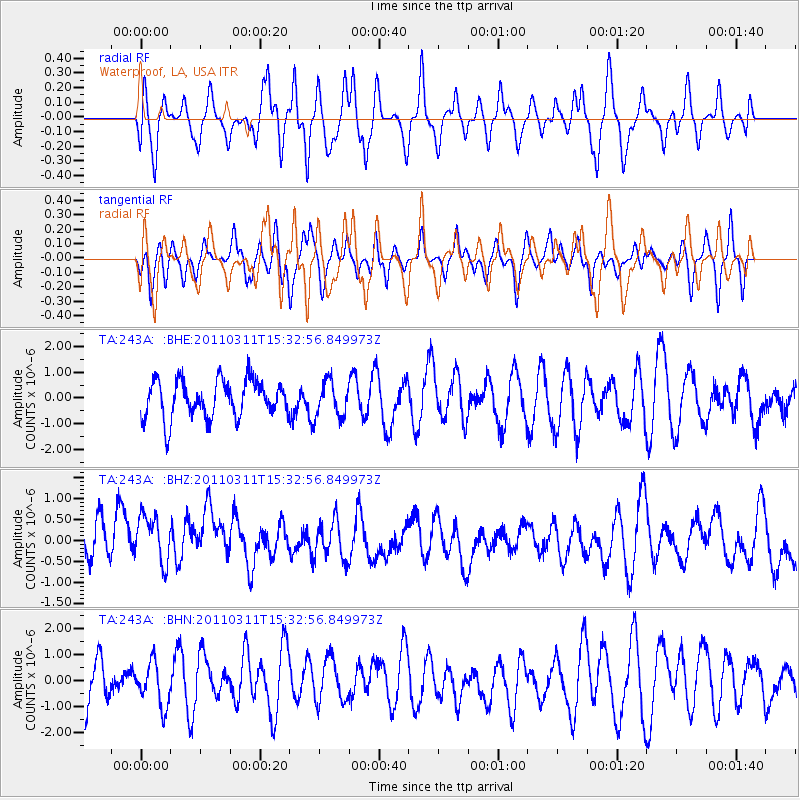
243A Waterproof, LA, USA - Earthquake Result Viewer
*The percent match for this event was below the threshold and hence no stack was calculated.
| Earthquake location: |
Near East Coast Of Honshu, Japan |
| Earthquake latitude/longitude: |
36.4/141.9 |
| Earthquake time(UTC): |
2011/03/11 (070) 15:20:08 GMT |
| Earthquake Depth: |
53 km |
| Earthquake Magnitude: |
6.0 MB |
| Earthquake Catalog/Contributor: |
WHDF/NEIC |
|
| Network: |
TA USArray Transportable Network (new EarthScope stations) |
| Station: |
243A Waterproof, LA, USA |
| Lat/Lon: |
31.88 N/91.48 W |
| Elevation: |
2.0 m |
|
| Distance: |
95.7 deg |
| Az: |
43.306 deg |
| Baz: |
319.422 deg |
| Ray Param: |
$rayparam |
*The percent match for this event was below the threshold and hence was not used in the summary stack. |
|
| Radial Match: |
57.26157 % |
| Radial Bump: |
400 |
| Transverse Match: |
36.04525 % |
| Transverse Bump: |
310 |
| SOD ConfigId: |
356183 |
| Insert Time: |
2011-08-17 08:09:41.435 +0000 |
| GWidth: |
2.5 |
| Max Bumps: |
400 |
| Tol: |
0.001 |
|
Signal To Noise
| Channel | StoN | STA | LTA |
| TA:243A: :BHZ:20110311T15:32:56.849973Z | 1.2133304 | 8.955529E-7 | 7.380948E-7 |
| TA:243A: :BHN:20110311T15:32:56.849973Z | 0.8715389 | 8.201695E-7 | 9.4105894E-7 |
| TA:243A: :BHE:20110311T15:32:56.849973Z | 0.93400806 | 6.8400675E-7 | 7.3233497E-7 |
| Arrivals |
| Ps | |
| PpPs | |
| PsPs/PpSs | |


