You are here: Home > Network List > US - United States National Seismic Network Stations List
> Station MNV Mina, Nevada, USA > Earthquake Result Viewer
MNV Mina, Nevada, USA - Earthquake Result Viewer
| Earthquake location: |
Colombia |
| Earthquake latitude/longitude: |
3.9/-76.0 |
| Earthquake time(UTC): |
2001/09/22 (265) 03:23:38 GMT |
| Earthquake Depth: |
179 km |
| Earthquake Magnitude: |
6.0 MB, 6.0 MW, 6.0 MW |
| Earthquake Catalog/Contributor: |
WHDF/NEIC |
|
| Network: |
US United States National Seismic Network |
| Station: |
MNV Mina, Nevada, USA |
| Lat/Lon: |
38.43 N/118.15 W |
| Elevation: |
1524 m |
|
| Distance: |
51.5 deg |
| Az: |
317.65 deg |
| Baz: |
121.149 deg |
| Ray Param: |
0.066725574 |
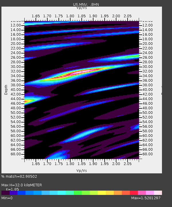
| Estimated Moho Depth: |
32.0 km |
| Estimated Crust Vp/Vs: |
1.85 |
| Assumed Crust Vp: |
6.279 km/s |
| Estimated Crust Vs: |
3.394 km/s |
| Estimated Crust Poisson's Ratio: |
0.29 |
|
| Radial Match: |
82.98502 % |
| Radial Bump: |
400 |
| Transverse Match: |
68.92844 % |
| Transverse Bump: |
400 |
| SOD ConfigId: |
110165 |
| Insert Time: |
2010-03-05 06:49:21.676 +0000 |
| GWidth: |
2.5 |
| Max Bumps: |
400 |
| Tol: |
0.001 |
|

Signal To Noise
| Channel | StoN | STA | LTA |
| US:MNV: :BHN:20010922T03:31:55.075011Z | 1.0379261 | 9.783909E-8 | 9.4264024E-8 |
| US:MNV: :BHE:20010922T03:31:55.075011Z | 1.2279105 | 1.0429615E-7 | 8.493791E-8 |
| US:MNV: :BHZ:20010922T03:31:55.075011Z | 2.9771423 | 2.6817838E-7 | 9.0079126E-8 |
| Arrivals |
| Ps | 4.6 SECOND |
| PpPs | 14 SECOND |
| PsPs/PpSs | 18 SECOND |


