You are here: Home > Network List > CC - Cascade Chain Volcano Monitoring Stations List
> Station PRLK Prince Lake > Earthquake Result Viewer
PRLK Prince Lake - Earthquake Result Viewer
| Earthquake location: |
Near Coast Of Chiapas, Mexico |
| Earthquake latitude/longitude: |
15.9/-93.4 |
| Earthquake time(UTC): |
2015/12/17 (351) 19:49:54 GMT |
| Earthquake Depth: |
97 km |
| Earthquake Magnitude: |
6.4 MWB, 6.6 MI |
| Earthquake Catalog/Contributor: |
NEIC PDE/NEIC COMCAT |
|
| Network: |
CC Cascade Chain Volcano Monitoring |
| Station: |
PRLK Prince Lake |
| Lat/Lon: |
44.21 N/121.96 W |
| Elevation: |
1283 m |
|
| Distance: |
37.2 deg |
| Az: |
325.335 deg |
| Baz: |
130.44 deg |
| Ray Param: |
0.07598026 |
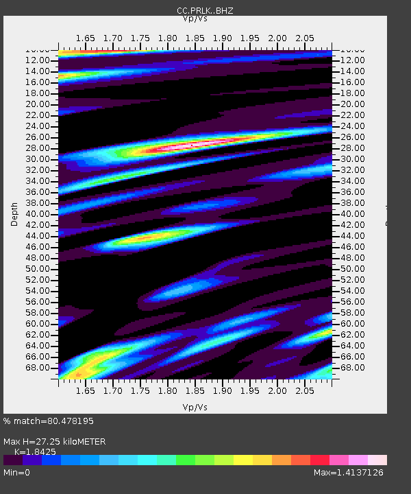
| Estimated Moho Depth: |
27.25 km |
| Estimated Crust Vp/Vs: |
1.84 |
| Assumed Crust Vp: |
6.597 km/s |
| Estimated Crust Vs: |
3.581 km/s |
| Estimated Crust Poisson's Ratio: |
0.29 |
|
| Radial Match: |
80.478195 % |
| Radial Bump: |
400 |
| Transverse Match: |
70.74402 % |
| Transverse Bump: |
400 |
| SOD ConfigId: |
7422571 |
| Insert Time: |
2019-04-21 14:37:36.010 +0000 |
| GWidth: |
2.5 |
| Max Bumps: |
400 |
| Tol: |
0.001 |
|

Signal To Noise
| Channel | StoN | STA | LTA |
| CC:PRLK: :BHZ:20151217T19:56:25.020005Z | 6.015314 | 3.5722176E-6 | 5.938539E-7 |
| CC:PRLK: :BHN:20151217T19:56:25.020005Z | 1.1201199 | 1.1107591E-6 | 9.91643E-7 |
| CC:PRLK: :BHE:20151217T19:56:25.020005Z | 1.1782852 | 9.4697936E-7 | 8.0369284E-7 |
| Arrivals |
| Ps | 3.7 SECOND |
| PpPs | 11 SECOND |
| PsPs/PpSs | 15 SECOND |


