You are here: Home > Network List > CC - Cascade Chain Volcano Monitoring Stations List
> Station PRLK Prince Lake > Earthquake Result Viewer
PRLK Prince Lake - Earthquake Result Viewer
| Earthquake location: |
Kermadec Islands Region |
| Earthquake latitude/longitude: |
-28.0/-176.4 |
| Earthquake time(UTC): |
2016/07/13 (195) 12:11:13 GMT |
| Earthquake Depth: |
12 km |
| Earthquake Magnitude: |
6.3 MWB |
| Earthquake Catalog/Contributor: |
NEIC PDE/NEIC COMCAT |
|
| Network: |
CC Cascade Chain Volcano Monitoring |
| Station: |
PRLK Prince Lake |
| Lat/Lon: |
44.21 N/121.96 W |
| Elevation: |
1283 m |
|
| Distance: |
87.4 deg |
| Az: |
35.837 deg |
| Baz: |
226.03 deg |
| Ray Param: |
0.043332543 |
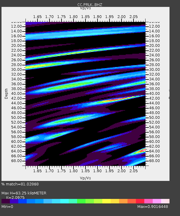
| Estimated Moho Depth: |
63.25 km |
| Estimated Crust Vp/Vs: |
2.10 |
| Assumed Crust Vp: |
6.597 km/s |
| Estimated Crust Vs: |
3.145 km/s |
| Estimated Crust Poisson's Ratio: |
0.35 |
|
| Radial Match: |
81.02868 % |
| Radial Bump: |
400 |
| Transverse Match: |
74.5378 % |
| Transverse Bump: |
400 |
| SOD ConfigId: |
11737051 |
| Insert Time: |
2019-04-25 02:03:24.818 +0000 |
| GWidth: |
2.5 |
| Max Bumps: |
400 |
| Tol: |
0.001 |
|

Signal To Noise
| Channel | StoN | STA | LTA |
| CC:PRLK: :BHZ:20160713T12:23:28.42002Z | 4.7422523 | 7.536915E-7 | 1.5893113E-7 |
| CC:PRLK: :BHN:20160713T12:23:28.42002Z | 0.7539883 | 1.939726E-7 | 2.572621E-7 |
| CC:PRLK: :BHE:20160713T12:23:28.42002Z | 1.2694086 | 2.3981102E-7 | 1.8891554E-7 |
| Arrivals |
| Ps | 11 SECOND |
| PpPs | 29 SECOND |
| PsPs/PpSs | 40 SECOND |


