You are here: Home > Network List > CC - Cascade Chain Volcano Monitoring Stations List
> Station PRLK Prince Lake > Earthquake Result Viewer
PRLK Prince Lake - Earthquake Result Viewer
| Earthquake location: |
Mariana Islands |
| Earthquake latitude/longitude: |
13.8/144.4 |
| Earthquake time(UTC): |
2014/09/17 (260) 06:14:46 GMT |
| Earthquake Depth: |
137 km |
| Earthquake Magnitude: |
6.7 MWC, 7.1 MI |
| Earthquake Catalog/Contributor: |
NEIC PDE/NEIC COMCAT |
|
| Network: |
CC Cascade Chain Volcano Monitoring |
| Station: |
PRLK Prince Lake |
| Lat/Lon: |
44.21 N/121.96 W |
| Elevation: |
1283 m |
|
| Distance: |
83.1 deg |
| Az: |
46.293 deg |
| Baz: |
282.376 deg |
| Ray Param: |
0.046099644 |
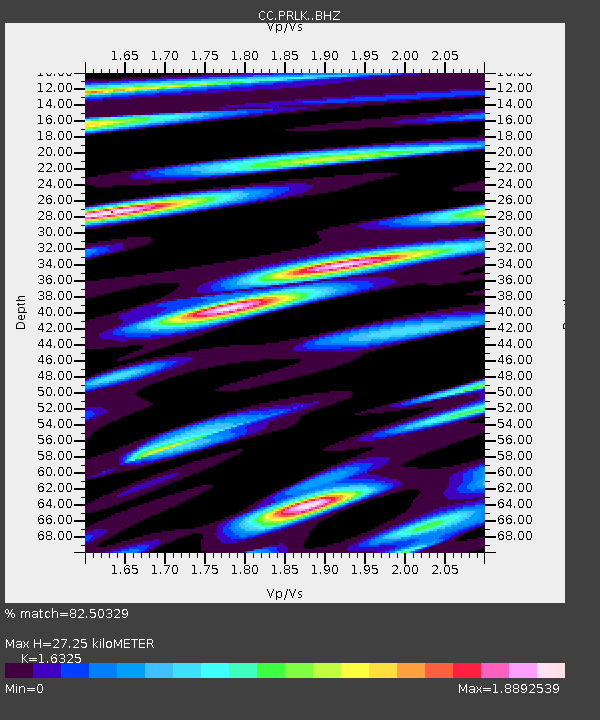
| Estimated Moho Depth: |
27.25 km |
| Estimated Crust Vp/Vs: |
1.63 |
| Assumed Crust Vp: |
6.597 km/s |
| Estimated Crust Vs: |
4.041 km/s |
| Estimated Crust Poisson's Ratio: |
0.20 |
|
| Radial Match: |
82.50329 % |
| Radial Bump: |
400 |
| Transverse Match: |
75.57405 % |
| Transverse Bump: |
400 |
| SOD ConfigId: |
3390531 |
| Insert Time: |
2019-04-14 02:28:22.146 +0000 |
| GWidth: |
2.5 |
| Max Bumps: |
400 |
| Tol: |
0.001 |
|

Signal To Noise
| Channel | StoN | STA | LTA |
| CC:PRLK: :BHZ:20140917T06:26:24.520007Z | 62.290855 | 1.41265E-5 | 2.2678289E-7 |
| CC:PRLK: :BHN:20140917T06:26:24.520007Z | 4.4096437 | 1.203491E-6 | 2.7292253E-7 |
| CC:PRLK: :BHE:20140917T06:26:24.520007Z | 7.8869786 | 4.5513107E-6 | 5.7706643E-7 |
| Arrivals |
| Ps | 2.7 SECOND |
| PpPs | 11 SECOND |
| PsPs/PpSs | 13 SECOND |


