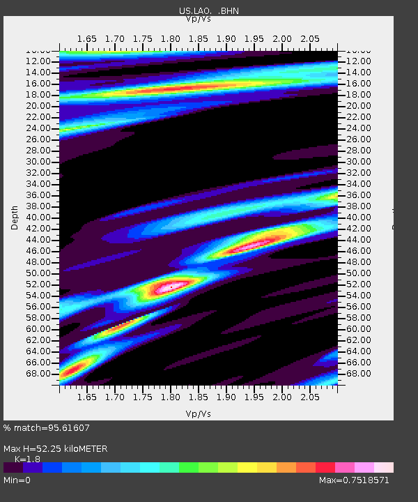
LAO LASA Array, Montana, USA - Earthquake Result Viewer

Earthquake location: Fox Islands, Aleutian Islands
Earthquake latitude/longitude: 52.5/-169.3
Earthquake time(UTC): 2006/05/10 (130) 02:42:51 GMT
Earthquake Depth: 18 km
Earthquake Magnitude: 6.1 MB, 6.2 MS, 6.4 MW, 6.3 MW
Earthquake Catalog/Contributor: WHDF/NEIC
Network: US United States National Seismic Network
Station: LAO LASA Array, Montana, USA
Lat/Lon: 46.69 N/106.22 W
Elevation: 902 m
Distance: 40.1 deg
Az: 72.269 deg
Baz: 302.266 deg
Ray Param: 0.07456556
Estimated Moho Depth: 52.25 km
Estimated Crust Vp/Vs: 1.80
Assumed Crust Vp: 6.438 km/s
Estimated Crust Vs: 3.576 km/s
Estimated Crust Poisson's Ratio: 0.28
Radial Match: 95.61607 %
Radial Bump: 263
Transverse Match: 86.60589 %
Transverse Bump: 400
SOD ConfigId: 2669
Insert Time: 2010-03-05 07:12:03.163 +0000
GWidth: 2.5
Max Bumps: 400
Tol: 0.001

Signal To Noise

ChannelStoNSTALTA
US:LAO: :BHN:20060510T02:49:54.673005Z1.7407163.2945684E-71.8926512E-7
US:LAO: :BHE:20060510T02:49:54.673005Z2.88295085.971305E-72.0712477E-7
US:LAO: :BHZ:20060510T02:49:54.673005Z8.5001198.8086915E-71.03630214E-7
Arrivals
Ps7.0 SECOND
PpPs21 SECOND
PsPs/PpSs28 SECOND