You are here: Home > Network List > TA - USArray Transportable Network (new EarthScope stations) Stations List
> Station B15A Bradely Ranch, Valier, MT, USA > Earthquake Result Viewer
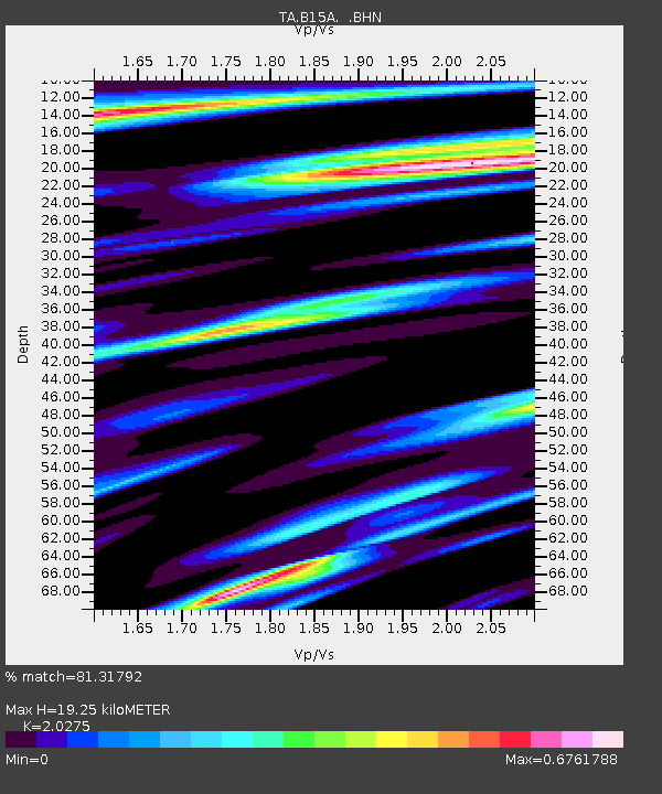
B15A Bradely Ranch, Valier, MT, USA - Earthquake Result Viewer
| Earthquake location: |
Bonin Islands, Japan Region |
| Earthquake latitude/longitude: |
26.8/142.4 |
| Earthquake time(UTC): |
2008/02/27 (058) 06:54:20 GMT |
| Earthquake Depth: |
15 km |
| Earthquake Magnitude: |
5.8 MB, 6.1 MS, 6.2 MW, 6.2 MW |
| Earthquake Catalog/Contributor: |
WHDF/NEIC |
|
| Network: |
TA USArray Transportable Network (new EarthScope stations) |
| Station: |
B15A Bradely Ranch, Valier, MT, USA |
| Lat/Lon: |
48.31 N/112.56 W |
| Elevation: |
1222 m |
|
| Distance: |
79.6 deg |
| Az: |
40.956 deg |
| Baz: |
298.657 deg |
| Ray Param: |
0.048807643 |
| Estimated Moho Depth: |
19.25 km |
| Estimated Crust Vp/Vs: |
2.03 |
| Assumed Crust Vp: |
6.178 km/s |
| Estimated Crust Vs: |
3.047 km/s |
| Estimated Crust Poisson's Ratio: |
0.34 |
|
| Radial Match: |
81.31792 % |
| Radial Bump: |
400 |
| Transverse Match: |
74.287445 % |
| Transverse Bump: |
400 |
| SOD ConfigId: |
2564 |
| Insert Time: |
2010-03-06 09:39:25.247 +0000 |
| GWidth: |
2.5 |
| Max Bumps: |
400 |
| Tol: |
0.001 |
|

Signal To Noise
| Channel | StoN | STA | LTA |
| TA:B15A: :BHN:20080227T07:05:55.899001Z | 1.3845433 | 2.5201075E-7 | 1.8201723E-7 |
| TA:B15A: :BHE:20080227T07:05:55.899001Z | 0.42167917 | 9.307228E-8 | 2.2071823E-7 |
| TA:B15A: :BHZ:20080227T07:05:55.899001Z | 2.4113128 | 5.023103E-7 | 2.0831402E-7 |
| Arrivals |
| Ps | 3.3 SECOND |
| PpPs | 9.2 SECOND |
| PsPs/PpSs | 12 SECOND |


