You are here: Home > Network List > TA - USArray Transportable Network (new EarthScope stations) Stations List
> Station B15A Bradely Ranch, Valier, MT, USA > Earthquake Result Viewer
B15A Bradely Ranch, Valier, MT, USA - Earthquake Result Viewer
| Earthquake location: |
Tonga Islands Region |
| Earthquake latitude/longitude: |
-23.0/-174.7 |
| Earthquake time(UTC): |
2009/03/19 (078) 18:17:40 GMT |
| Earthquake Depth: |
34 km |
| Earthquake Magnitude: |
7.0 MB, 7.6 MS, 7.6 MW, 7.6 MW |
| Earthquake Catalog/Contributor: |
WHDF/NEIC |
|
| Network: |
TA USArray Transportable Network (new EarthScope stations) |
| Station: |
B15A Bradely Ranch, Valier, MT, USA |
| Lat/Lon: |
48.31 N/112.56 W |
| Elevation: |
1222 m |
|
| Distance: |
90.1 deg |
| Az: |
36.153 deg |
| Baz: |
234.493 deg |
| Ray Param: |
0.041692033 |
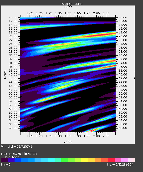
| Estimated Moho Depth: |
69.75 km |
| Estimated Crust Vp/Vs: |
1.96 |
| Assumed Crust Vp: |
6.178 km/s |
| Estimated Crust Vs: |
3.156 km/s |
| Estimated Crust Poisson's Ratio: |
0.32 |
|
| Radial Match: |
95.725746 % |
| Radial Bump: |
400 |
| Transverse Match: |
87.82377 % |
| Transverse Bump: |
400 |
| SOD ConfigId: |
2658 |
| Insert Time: |
2010-03-06 09:39:55.882 +0000 |
| GWidth: |
2.5 |
| Max Bumps: |
400 |
| Tol: |
0.001 |
|

Signal To Noise
| Channel | StoN | STA | LTA |
| TA:B15A: :BHN:20090319T18:30:06.199001Z | 19.733387 | 4.4897506E-6 | 2.2752053E-7 |
| TA:B15A: :BHE:20090319T18:30:06.199001Z | 8.233685 | 8.9104236E-7 | 1.0821915E-7 |
| TA:B15A: :BHZ:20090319T18:30:06.199001Z | 5.5199676 | 9.042469E-7 | 1.6381381E-7 |
| Arrivals |
| Ps | 11 SECOND |
| PpPs | 33 SECOND |
| PsPs/PpSs | 44 SECOND |


