You are here: Home > Network List > TA - USArray Transportable Network (new EarthScope stations) Stations List
> Station B15A Bradely Ranch, Valier, MT, USA > Earthquake Result Viewer
B15A Bradely Ranch, Valier, MT, USA - Earthquake Result Viewer
| Earthquake location: |
Near Coast Of Northern Chile |
| Earthquake latitude/longitude: |
-22.9/-70.2 |
| Earthquake time(UTC): |
2007/11/15 (319) 15:05:58 GMT |
| Earthquake Depth: |
26 km |
| Earthquake Magnitude: |
6.1 MB, 6.6 MS, 6.8 MW, 6.6 MW |
| Earthquake Catalog/Contributor: |
WHDF/NEIC |
|
| Network: |
TA USArray Transportable Network (new EarthScope stations) |
| Station: |
B15A Bradely Ranch, Valier, MT, USA |
| Lat/Lon: |
48.31 N/112.56 W |
| Elevation: |
1222 m |
|
| Distance: |
80.4 deg |
| Az: |
332.88 deg |
| Baz: |
140.981 deg |
| Ray Param: |
0.04826721 |
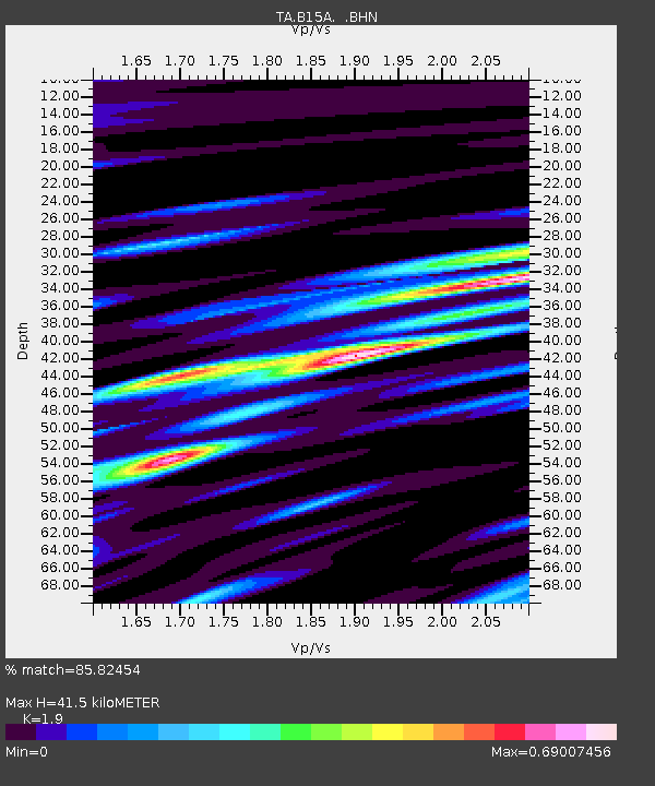
| Estimated Moho Depth: |
41.5 km |
| Estimated Crust Vp/Vs: |
1.90 |
| Assumed Crust Vp: |
6.178 km/s |
| Estimated Crust Vs: |
3.252 km/s |
| Estimated Crust Poisson's Ratio: |
0.31 |
|
| Radial Match: |
85.82454 % |
| Radial Bump: |
400 |
| Transverse Match: |
78.22101 % |
| Transverse Bump: |
400 |
| SOD ConfigId: |
2564 |
| Insert Time: |
2010-03-06 09:40:16.544 +0000 |
| GWidth: |
2.5 |
| Max Bumps: |
400 |
| Tol: |
0.001 |
|

Signal To Noise
| Channel | StoN | STA | LTA |
| TA:B15A: :BHN:20071115T15:17:36.250024Z | 0.81780374 | 3.279832E-7 | 4.0105368E-7 |
| TA:B15A: :BHE:20071115T15:17:36.250024Z | 1.007534 | 3.0820283E-7 | 3.058982E-7 |
| TA:B15A: :BHZ:20071115T15:17:36.250024Z | 2.3444986 | 8.604308E-7 | 3.6699993E-7 |
| Arrivals |
| Ps | 6.2 SECOND |
| PpPs | 19 SECOND |
| PsPs/PpSs | 25 SECOND |


