You are here: Home > Network List > TA - USArray Transportable Network (new EarthScope stations) Stations List
> Station B15A Bradely Ranch, Valier, MT, USA > Earthquake Result Viewer
B15A Bradely Ranch, Valier, MT, USA - Earthquake Result Viewer
| Earthquake location: |
Solomon Islands |
| Earthquake latitude/longitude: |
-10.5/161.3 |
| Earthquake time(UTC): |
2008/06/03 (155) 16:20:50 GMT |
| Earthquake Depth: |
84 km |
| Earthquake Magnitude: |
6.2 MB, 6.2 MW, 6.2 MW |
| Earthquake Catalog/Contributor: |
WHDF/NEIC |
|
| Network: |
TA USArray Transportable Network (new EarthScope stations) |
| Station: |
B15A Bradely Ranch, Valier, MT, USA |
| Lat/Lon: |
48.31 N/112.56 W |
| Elevation: |
1222 m |
|
| Distance: |
95.2 deg |
| Az: |
41.977 deg |
| Baz: |
260.175 deg |
| Ray Param: |
0.04078248 |
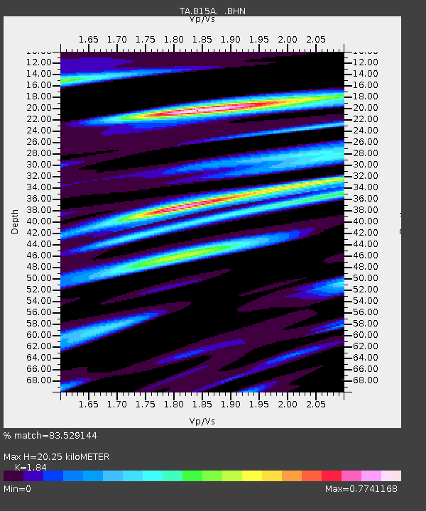
| Estimated Moho Depth: |
20.25 km |
| Estimated Crust Vp/Vs: |
1.84 |
| Assumed Crust Vp: |
6.178 km/s |
| Estimated Crust Vs: |
3.358 km/s |
| Estimated Crust Poisson's Ratio: |
0.29 |
|
| Radial Match: |
83.529144 % |
| Radial Bump: |
363 |
| Transverse Match: |
81.55024 % |
| Transverse Bump: |
396 |
| SOD ConfigId: |
2504 |
| Insert Time: |
2010-03-06 09:40:54.911 +0000 |
| GWidth: |
2.5 |
| Max Bumps: |
400 |
| Tol: |
0.001 |
|

Signal To Noise
| Channel | StoN | STA | LTA |
| TA:B15A: :BHN:20080603T16:33:33.27502Z | 16.116903 | 8.5519804E-7 | 5.306218E-8 |
| TA:B15A: :BHE:20080603T16:33:33.27502Z | 1.9243798 | 1.1890205E-7 | 6.1787205E-8 |
| TA:B15A: :BHZ:20080603T16:33:33.27502Z | 4.421047 | 2.3590842E-7 | 5.3360303E-8 |
| Arrivals |
| Ps | 2.8 SECOND |
| PpPs | 9.1 SECOND |
| PsPs/PpSs | 12 SECOND |


