You are here: Home > Network List > US - United States National Seismic Network Stations List
> Station LAO LASA Array, Montana, USA > Earthquake Result Viewer
LAO LASA Array, Montana, USA - Earthquake Result Viewer
| Earthquake location: |
Tonga Islands |
| Earthquake latitude/longitude: |
-19.4/-174.9 |
| Earthquake time(UTC): |
2024/05/26 (147) 20:47:09 GMT |
| Earthquake Depth: |
112 km |
| Earthquake Magnitude: |
6.6 mww |
| Earthquake Catalog/Contributor: |
NEIC PDE/us |
|
| Network: |
US United States National Seismic Network |
| Station: |
LAO LASA Array, Montana, USA |
| Lat/Lon: |
46.69 N/106.22 W |
| Elevation: |
902 m |
|
| Distance: |
90.1 deg |
| Az: |
39.877 deg |
| Baz: |
241.551 deg |
| Ray Param: |
0.041702267 |
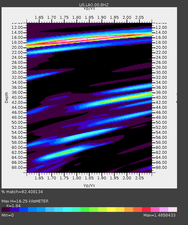
| Estimated Moho Depth: |
16.25 km |
| Estimated Crust Vp/Vs: |
1.84 |
| Assumed Crust Vp: |
6.438 km/s |
| Estimated Crust Vs: |
3.499 km/s |
| Estimated Crust Poisson's Ratio: |
0.29 |
|
| Radial Match: |
92.408134 % |
| Radial Bump: |
400 |
| Transverse Match: |
83.37144 % |
| Transverse Bump: |
400 |
| SOD ConfigId: |
35001331 |
| Insert Time: |
2024-06-09 21:25:42.282 +0000 |
| GWidth: |
2.5 |
| Max Bumps: |
400 |
| Tol: |
0.001 |
|

Signal To Noise
| Channel | StoN | STA | LTA |
| US:LAO:00:BHZ:20240526T20:59:25.599027Z | 33.535297 | 3.318099E-6 | 9.8943474E-8 |
| US:LAO:00:BH1:20240526T20:59:25.599027Z | 5.626176 | 8.6997284E-7 | 1.546295E-7 |
| US:LAO:00:BH2:20240526T20:59:25.599027Z | 2.063126 | 4.7364793E-7 | 2.2957781E-7 |
| Arrivals |
| Ps | 2.2 SECOND |
| PpPs | 7.0 SECOND |
| PsPs/PpSs | 9.2 SECOND |


