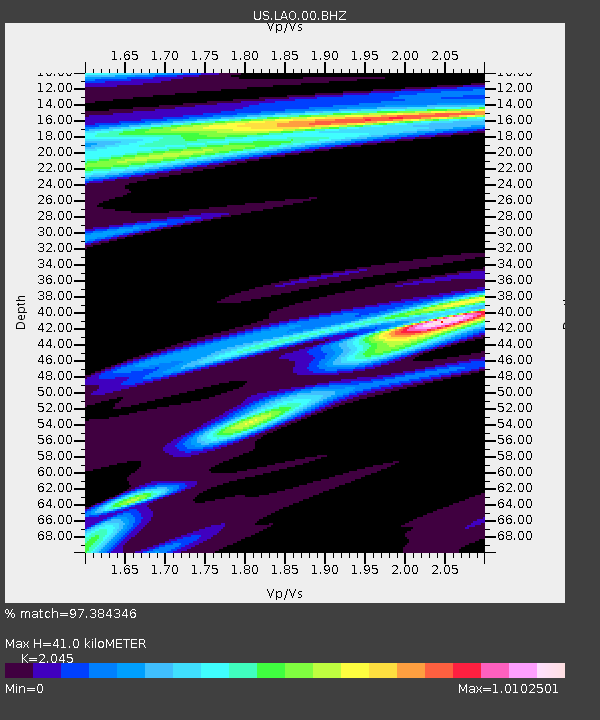
LAO LASA Array, Montana, USA - Earthquake Result Viewer

Earthquake location: Off East Coast Of Honshu, Japan
Earthquake latitude/longitude: 40.9/144.9
Earthquake time(UTC): 2012/03/14 (074) 09:08:35 GMT
Earthquake Depth: 12 km
Earthquake Magnitude: 6.7 MB, 6.9 MS, 6.9 MW, 7.0 MW
Earthquake Catalog/Contributor: WHDF/NEIC
Network: US United States National Seismic Network
Station: LAO LASA Array, Montana, USA
Lat/Lon: 46.69 N/106.22 W
Elevation: 902 m
Distance: 72.3 deg
Az: 43.159 deg
Baz: 311.118 deg
Ray Param: 0.053765804
Estimated Moho Depth: 41.0 km
Estimated Crust Vp/Vs: 2.05
Assumed Crust Vp: 6.438 km/s
Estimated Crust Vs: 3.148 km/s
Estimated Crust Poisson's Ratio: 0.34
Radial Match: 97.384346 %
Radial Bump: 289
Transverse Match: 90.55782 %
Transverse Bump: 400
SOD ConfigId: 558545
Insert Time: 2013-09-19 13:42:21.108 +0000
GWidth: 2.5
Max Bumps: 400
Tol: 0.001

Signal To Noise

ChannelStoNSTALTA
US:LAO:00:BHZ:20120314T09:19:28.999009Z10.5894811.8475675E-61.7447196E-7
US:LAO:00:BH1:20120314T09:19:28.999009Z2.72476895.8576586E-72.1497819E-7
US:LAO:00:BH2:20120314T09:19:28.999009Z2.307256.4977354E-72.816225E-7
Arrivals
Ps6.9 SECOND
PpPs19 SECOND
PsPs/PpSs26 SECOND