You are here: Home > Network List > KO - Kandilli Observatory Digital Broadband Seismic Network Stations List
> Station BNN Bunyan-Kayseri-Turkey > Earthquake Result Viewer
BNN Bunyan-Kayseri-Turkey - Earthquake Result Viewer
| Earthquake location: |
Andreanof Islands, Aleutian Is. |
| Earthquake latitude/longitude: |
51.5/-173.0 |
| Earthquake time(UTC): |
2015/11/08 (312) 11:33:16 GMT |
| Earthquake Depth: |
34 km |
| Earthquake Magnitude: |
5.7 MWP, 5.6 MI |
| Earthquake Catalog/Contributor: |
NEIC PDE/NEIC COMCAT |
|
| Network: |
KO Kandilli Observatory Digital Broadband Seismic Network |
| Station: |
BNN Bunyan-Kayseri-Turkey |
| Lat/Lon: |
38.85 N/35.85 E |
| Elevation: |
1380 m |
|
| Distance: |
86.6 deg |
| Az: |
337.841 deg |
| Baz: |
17.574 deg |
| Ray Param: |
0.04392263 |
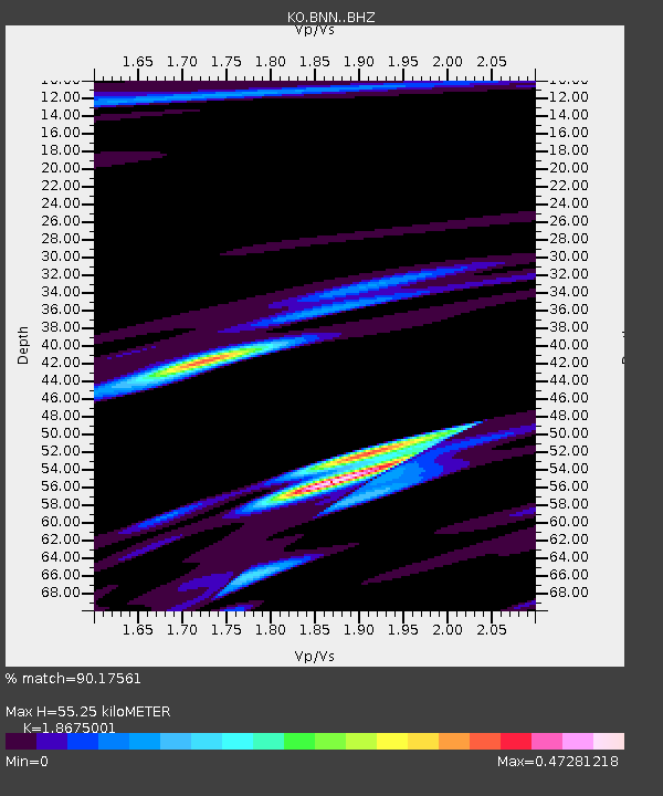
| Estimated Moho Depth: |
55.25 km |
| Estimated Crust Vp/Vs: |
1.87 |
| Assumed Crust Vp: |
6.35 km/s |
| Estimated Crust Vs: |
3.4 km/s |
| Estimated Crust Poisson's Ratio: |
0.30 |
|
| Radial Match: |
90.17561 % |
| Radial Bump: |
400 |
| Transverse Match: |
79.01098 % |
| Transverse Bump: |
400 |
| SOD ConfigId: |
7422571 |
| Insert Time: |
2019-04-21 07:23:33.437 +0000 |
| GWidth: |
2.5 |
| Max Bumps: |
400 |
| Tol: |
0.001 |
|

Signal To Noise
| Channel | StoN | STA | LTA |
| KO:BNN: :BHZ:20151108T11:45:24.580007Z | 4.713924 | 1.4949334E-6 | 3.1713142E-7 |
| KO:BNN: :BHN:20151108T11:45:24.580007Z | 1.7692579 | 4.925925E-7 | 2.784176E-7 |
| KO:BNN: :BHE:20151108T11:45:24.580007Z | 3.3746443 | 6.507705E-7 | 1.9284121E-7 |
| Arrivals |
| Ps | 7.7 SECOND |
| PpPs | 24 SECOND |
| PsPs/PpSs | 32 SECOND |


