You are here: Home > Network List > KO - Kandilli Observatory Digital Broadband Seismic Network Stations List
> Station BNN Bunyan-Kayseri-Turkey > Earthquake Result Viewer
BNN Bunyan-Kayseri-Turkey - Earthquake Result Viewer
| Earthquake location: |
Northwest Of Ryukyu Islands |
| Earthquake latitude/longitude: |
31.1/128.8 |
| Earthquake time(UTC): |
2015/11/13 (317) 20:51:32 GMT |
| Earthquake Depth: |
10 km |
| Earthquake Magnitude: |
6.5 MWB |
| Earthquake Catalog/Contributor: |
NEIC PDE/NEIC COMCAT |
|
| Network: |
KO Kandilli Observatory Digital Broadband Seismic Network |
| Station: |
BNN Bunyan-Kayseri-Turkey |
| Lat/Lon: |
38.85 N/35.85 E |
| Elevation: |
1380 m |
|
| Distance: |
73.4 deg |
| Az: |
305.534 deg |
| Baz: |
63.429 deg |
| Ray Param: |
0.053042732 |
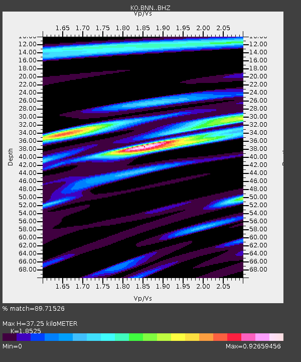
| Estimated Moho Depth: |
37.25 km |
| Estimated Crust Vp/Vs: |
1.85 |
| Assumed Crust Vp: |
6.35 km/s |
| Estimated Crust Vs: |
3.428 km/s |
| Estimated Crust Poisson's Ratio: |
0.29 |
|
| Radial Match: |
89.71526 % |
| Radial Bump: |
400 |
| Transverse Match: |
85.86974 % |
| Transverse Bump: |
400 |
| SOD ConfigId: |
7422571 |
| Insert Time: |
2019-04-21 09:05:08.923 +0000 |
| GWidth: |
2.5 |
| Max Bumps: |
400 |
| Tol: |
0.001 |
|

Signal To Noise
| Channel | StoN | STA | LTA |
| KO:BNN: :BHZ:20151113T21:02:31.860002Z | 1.4078965 | 3.0868011E-7 | 2.1924915E-7 |
| KO:BNN: :BHN:20151113T21:02:31.860002Z | 0.9757916 | 2.3028873E-7 | 2.3600197E-7 |
| KO:BNN: :BHE:20151113T21:02:31.860002Z | 0.5614645 | 1.7909399E-7 | 3.1897653E-7 |
| Arrivals |
| Ps | 5.2 SECOND |
| PpPs | 16 SECOND |
| PsPs/PpSs | 21 SECOND |


