You are here: Home > Network List > KO - Kandilli Observatory Digital Broadband Seismic Network Stations List
> Station BNN Bunyan-Kayseri-Turkey > Earthquake Result Viewer
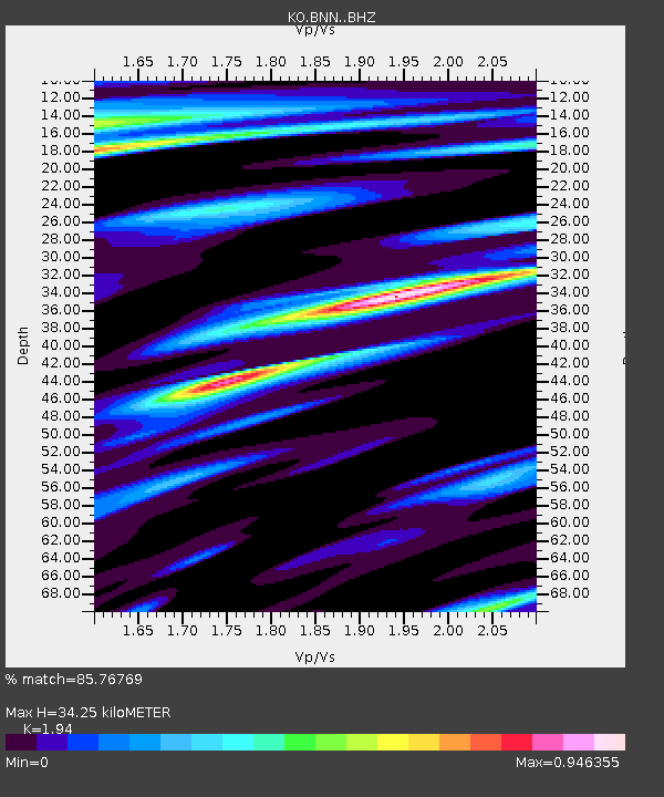
BNN Bunyan-Kayseri-Turkey - Earthquake Result Viewer
| Earthquake location: |
Strait Of Gibraltar |
| Earthquake latitude/longitude: |
35.7/-3.6 |
| Earthquake time(UTC): |
2016/01/25 (025) 04:22:02 GMT |
| Earthquake Depth: |
10 km |
| Earthquake Magnitude: |
6.1 MWP |
| Earthquake Catalog/Contributor: |
NEIC PDE/NEIC COMCAT |
|
| Network: |
KO Kandilli Observatory Digital Broadband Seismic Network |
| Station: |
BNN Bunyan-Kayseri-Turkey |
| Lat/Lon: |
38.85 N/35.85 E |
| Elevation: |
1380 m |
|
| Distance: |
31.4 deg |
| Az: |
72.375 deg |
| Baz: |
276.794 deg |
| Ray Param: |
0.07908816 |
| Estimated Moho Depth: |
34.25 km |
| Estimated Crust Vp/Vs: |
1.94 |
| Assumed Crust Vp: |
6.35 km/s |
| Estimated Crust Vs: |
3.273 km/s |
| Estimated Crust Poisson's Ratio: |
0.32 |
|
| Radial Match: |
85.76769 % |
| Radial Bump: |
400 |
| Transverse Match: |
74.10333 % |
| Transverse Bump: |
360 |
| SOD ConfigId: |
7422571 |
| Insert Time: |
2019-04-21 20:00:07.436 +0000 |
| GWidth: |
2.5 |
| Max Bumps: |
400 |
| Tol: |
0.001 |
|

Signal To Noise
| Channel | StoN | STA | LTA |
| KO:BNN: :BHZ:20160125T04:27:53.340005Z | 4.5498466 | 2.7973854E-6 | 6.148307E-7 |
| KO:BNN: :BHN:20160125T04:27:53.340005Z | 0.822128 | 4.252399E-7 | 5.1724294E-7 |
| KO:BNN: :BHE:20160125T04:27:53.340005Z | 2.4971025 | 1.7402031E-6 | 6.9688895E-7 |
| Arrivals |
| Ps | 5.4 SECOND |
| PpPs | 15 SECOND |
| PsPs/PpSs | 20 SECOND |


