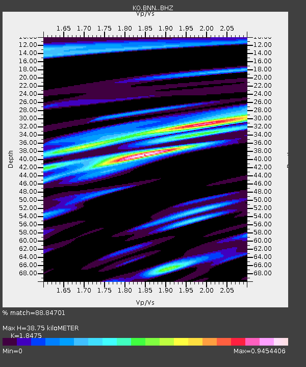
BNN Bunyan-Kayseri-Turkey - Earthquake Result Viewer

Earthquake location: Andreanof Islands, Aleutian Is.
Earthquake latitude/longitude: 51.6/-174.0
Earthquake time(UTC): 2016/03/12 (072) 18:06:45 GMT
Earthquake Depth: 19 km
Earthquake Magnitude: 6.3 MWW, 6.1 MB, 6.2 MWB, 6.3 MWC, 6.4 MWC, 6.4 MI
Earthquake Catalog/Contributor: NEIC PDE/NEIC COMCAT
Network: KO Kandilli Observatory Digital Broadband Seismic Network
Station: BNN Bunyan-Kayseri-Turkey
Lat/Lon: 38.85 N/35.85 E
Elevation: 1380 m
Distance: 86.2 deg
Az: 337.061 deg
Baz: 18.156 deg
Ray Param: 0.04417135
Estimated Moho Depth: 38.75 km
Estimated Crust Vp/Vs: 1.85
Assumed Crust Vp: 6.35 km/s
Estimated Crust Vs: 3.437 km/s
Estimated Crust Poisson's Ratio: 0.29
Radial Match: 88.84701 %
Radial Bump: 400
Transverse Match: 85.64527 %
Transverse Bump: 400
SOD ConfigId: 7422571
Insert Time: 2019-04-22 00:41:33.301 +0000
GWidth: 2.5
Max Bumps: 400
Tol: 0.001

Signal To Noise

ChannelStoNSTALTA
KO:BNN: :BHZ:20160312T18:18:53.639971Z14.8341542.0754464E-61.3990999E-7
KO:BNN: :BHN:20160312T18:18:53.639971Z5.86955177.725686E-71.3162311E-7
KO:BNN: :BHE:20160312T18:18:53.639971Z1.99515254.1690762E-72.0896027E-7
Arrivals
Ps5.3 SECOND
PpPs17 SECOND
PsPs/PpSs22 SECOND