You are here: Home > Network List > KO - Kandilli Observatory Digital Broadband Seismic Network Stations List
> Station BNN Bunyan-Kayseri-Turkey > Earthquake Result Viewer
BNN Bunyan-Kayseri-Turkey - Earthquake Result Viewer
| Earthquake location: |
South Of Sumbawa, Indonesia |
| Earthquake latitude/longitude: |
-11.5/116.2 |
| Earthquake time(UTC): |
2016/06/09 (161) 04:13:08 GMT |
| Earthquake Depth: |
30 km |
| Earthquake Magnitude: |
6.2 MWP |
| Earthquake Catalog/Contributor: |
NEIC PDE/NEIC COMCAT |
|
| Network: |
KO Kandilli Observatory Digital Broadband Seismic Network |
| Station: |
BNN Bunyan-Kayseri-Turkey |
| Lat/Lon: |
38.85 N/35.85 E |
| Elevation: |
1380 m |
|
| Distance: |
89.7 deg |
| Az: |
309.659 deg |
| Baz: |
104.863 deg |
| Ray Param: |
0.041719317 |
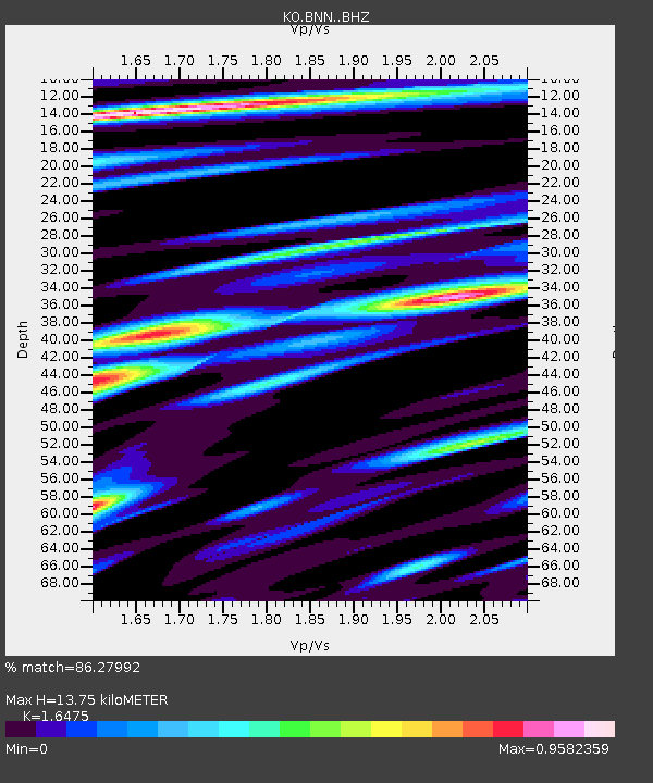
| Estimated Moho Depth: |
13.75 km |
| Estimated Crust Vp/Vs: |
1.65 |
| Assumed Crust Vp: |
6.35 km/s |
| Estimated Crust Vs: |
3.854 km/s |
| Estimated Crust Poisson's Ratio: |
0.21 |
|
| Radial Match: |
86.27992 % |
| Radial Bump: |
400 |
| Transverse Match: |
73.33266 % |
| Transverse Bump: |
400 |
| SOD ConfigId: |
7422571 |
| Insert Time: |
2019-04-22 19:27:56.263 +0000 |
| GWidth: |
2.5 |
| Max Bumps: |
400 |
| Tol: |
0.001 |
|

Signal To Noise
| Channel | StoN | STA | LTA |
| KO:BNN: :BHZ:20160609T04:25:33.060024Z | 4.447312 | 1.3027152E-6 | 2.9292192E-7 |
| KO:BNN: :BHN:20160609T04:25:33.060024Z | 0.7767412 | 1.8520805E-7 | 2.3844242E-7 |
| KO:BNN: :BHE:20160609T04:25:33.060024Z | 3.5054145 | 4.5549896E-7 | 1.2994154E-7 |
| Arrivals |
| Ps | 1.4 SECOND |
| PpPs | 5.6 SECOND |
| PsPs/PpSs | 7.0 SECOND |


