You are here: Home > Network List > KO - Kandilli Observatory Digital Broadband Seismic Network Stations List
> Station BNN Bunyan-Kayseri-Turkey > Earthquake Result Viewer
BNN Bunyan-Kayseri-Turkey - Earthquake Result Viewer
| Earthquake location: |
Northern Sumatra, Indonesia |
| Earthquake latitude/longitude: |
5.3/96.1 |
| Earthquake time(UTC): |
2016/12/06 (341) 22:03:32 GMT |
| Earthquake Depth: |
8.2 km |
| Earthquake Magnitude: |
6.5 Mww |
| Earthquake Catalog/Contributor: |
NEIC PDE/us |
|
| Network: |
KO Kandilli Observatory Digital Broadband Seismic Network |
| Station: |
BNN Bunyan-Kayseri-Turkey |
| Lat/Lon: |
38.85 N/35.85 E |
| Elevation: |
1380 m |
|
| Distance: |
63.7 deg |
| Az: |
310.873 deg |
| Baz: |
105.342 deg |
| Ray Param: |
0.05940122 |
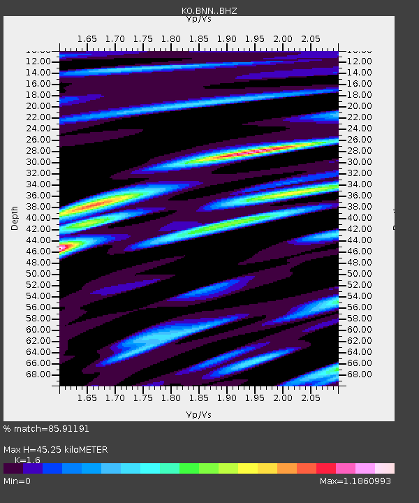
| Estimated Moho Depth: |
45.25 km |
| Estimated Crust Vp/Vs: |
1.60 |
| Assumed Crust Vp: |
6.35 km/s |
| Estimated Crust Vs: |
3.969 km/s |
| Estimated Crust Poisson's Ratio: |
0.18 |
|
| Radial Match: |
85.91191 % |
| Radial Bump: |
400 |
| Transverse Match: |
71.663895 % |
| Transverse Bump: |
400 |
| SOD ConfigId: |
11737051 |
| Insert Time: |
2019-04-26 05:37:47.558 +0000 |
| GWidth: |
2.5 |
| Max Bumps: |
400 |
| Tol: |
0.001 |
|

Signal To Noise
| Channel | StoN | STA | LTA |
| KO:BNN: :BHZ:20161206T22:13:33.70001Z | 11.713616 | 2.7852054E-6 | 2.3777501E-7 |
| KO:BNN: :BHN:20161206T22:13:33.70001Z | 1.3808774 | 2.5582167E-7 | 1.8526025E-7 |
| KO:BNN: :BHE:20161206T22:13:33.70001Z | 4.955768 | 9.985696E-7 | 2.0149643E-7 |
| Arrivals |
| Ps | 4.5 SECOND |
| PpPs | 18 SECOND |
| PsPs/PpSs | 22 SECOND |


