You are here: Home > Network List > KO - Kandilli Observatory Digital Broadband Seismic Network Stations List
> Station BNN Bunyan-Kayseri-Turkey > Earthquake Result Viewer
BNN Bunyan-Kayseri-Turkey - Earthquake Result Viewer
| Earthquake location: |
Southern Sumatra, Indonesia |
| Earthquake latitude/longitude: |
-3.8/101.6 |
| Earthquake time(UTC): |
2017/08/13 (225) 03:08:11 GMT |
| Earthquake Depth: |
36 km |
| Earthquake Magnitude: |
6.4 Mww |
| Earthquake Catalog/Contributor: |
NEIC PDE/us |
|
| Network: |
KO Kandilli Observatory Digital Broadband Seismic Network |
| Station: |
BNN Bunyan-Kayseri-Turkey |
| Lat/Lon: |
38.85 N/35.85 E |
| Elevation: |
1380 m |
|
| Distance: |
73.8 deg |
| Az: |
312.153 deg |
| Baz: |
108.665 deg |
| Ray Param: |
0.0527035 |
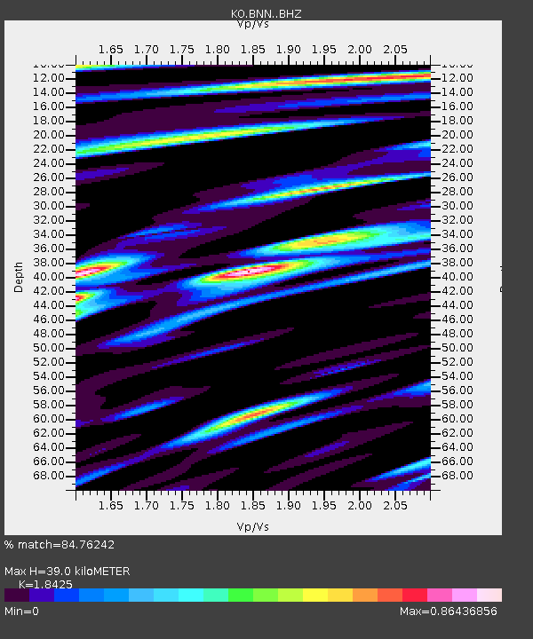
| Estimated Moho Depth: |
39.0 km |
| Estimated Crust Vp/Vs: |
1.84 |
| Assumed Crust Vp: |
6.35 km/s |
| Estimated Crust Vs: |
3.446 km/s |
| Estimated Crust Poisson's Ratio: |
0.29 |
|
| Radial Match: |
84.76242 % |
| Radial Bump: |
400 |
| Transverse Match: |
83.231514 % |
| Transverse Bump: |
400 |
| SOD ConfigId: |
13570011 |
| Insert Time: |
2019-04-28 14:18:06.017 +0000 |
| GWidth: |
2.5 |
| Max Bumps: |
400 |
| Tol: |
0.001 |
|

Signal To Noise
| Channel | StoN | STA | LTA |
| KO:BNN: :BHZ:20170813T03:19:10.93998Z | 30.426691 | 4.332322E-6 | 1.4238557E-7 |
| KO:BNN: :BHN:20170813T03:19:10.93998Z | 1.7776124 | 1.9933364E-7 | 1.121356E-7 |
| KO:BNN: :BHE:20170813T03:19:10.93998Z | 8.892376 | 1.4816286E-6 | 1.6661787E-7 |
| Arrivals |
| Ps | 5.3 SECOND |
| PpPs | 17 SECOND |
| PsPs/PpSs | 22 SECOND |


