You are here: Home > Network List > KO - Kandilli Observatory Digital Broadband Seismic Network Stations List
> Station BNN Bunyan-Kayseri-Turkey > Earthquake Result Viewer
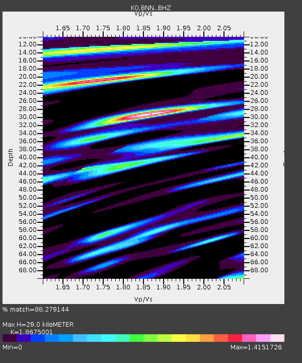
BNN Bunyan-Kayseri-Turkey - Earthquake Result Viewer
| Earthquake location: |
Myanmar-India Border Region |
| Earthquake latitude/longitude: |
24.8/94.9 |
| Earthquake time(UTC): |
2018/01/07 (007) 06:47:14 GMT |
| Earthquake Depth: |
23 km |
| Earthquake Magnitude: |
5.5 Mww |
| Earthquake Catalog/Contributor: |
NEIC PDE/us |
|
| Network: |
KO Kandilli Observatory Digital Broadband Seismic Network |
| Station: |
BNN Bunyan-Kayseri-Turkey |
| Lat/Lon: |
38.85 N/35.85 E |
| Elevation: |
1380 m |
|
| Distance: |
51.3 deg |
| Az: |
300.901 deg |
| Baz: |
87.564 deg |
| Ray Param: |
0.067462325 |
| Estimated Moho Depth: |
29.0 km |
| Estimated Crust Vp/Vs: |
1.87 |
| Assumed Crust Vp: |
6.35 km/s |
| Estimated Crust Vs: |
3.4 km/s |
| Estimated Crust Poisson's Ratio: |
0.30 |
|
| Radial Match: |
88.279144 % |
| Radial Bump: |
400 |
| Transverse Match: |
77.217705 % |
| Transverse Bump: |
400 |
| SOD ConfigId: |
13570011 |
| Insert Time: |
2019-04-29 12:43:51.084 +0000 |
| GWidth: |
2.5 |
| Max Bumps: |
400 |
| Tol: |
0.001 |
|

Signal To Noise
| Channel | StoN | STA | LTA |
| KO:BNN: :BHZ:20180107T06:55:45.819989Z | 13.825651 | 3.413018E-6 | 2.4686128E-7 |
| KO:BNN: :BHN:20180107T06:55:45.819989Z | 3.1127656 | 6.789337E-7 | 2.1811269E-7 |
| KO:BNN: :BHE:20180107T06:55:45.819989Z | 5.7907424 | 1.3145369E-6 | 2.2700664E-7 |
| Arrivals |
| Ps | 4.2 SECOND |
| PpPs | 12 SECOND |
| PsPs/PpSs | 17 SECOND |


