You are here: Home > Network List > KO - Kandilli Observatory Digital Broadband Seismic Network Stations List
> Station BNN Bunyan-Kayseri-Turkey > Earthquake Result Viewer
BNN Bunyan-Kayseri-Turkey - Earthquake Result Viewer
| Earthquake location: |
Hokkaido, Japan Region |
| Earthquake latitude/longitude: |
41.1/142.3 |
| Earthquake time(UTC): |
2018/01/24 (024) 10:51:20 GMT |
| Earthquake Depth: |
40 km |
| Earthquake Magnitude: |
6.2 Mww |
| Earthquake Catalog/Contributor: |
NEIC PDE/us |
|
| Network: |
KO Kandilli Observatory Digital Broadband Seismic Network |
| Station: |
BNN Bunyan-Kayseri-Turkey |
| Lat/Lon: |
38.85 N/35.85 E |
| Elevation: |
1380 m |
|
| Distance: |
76.0 deg |
| Az: |
309.478 deg |
| Baz: |
48.317 deg |
| Ray Param: |
0.05123933 |
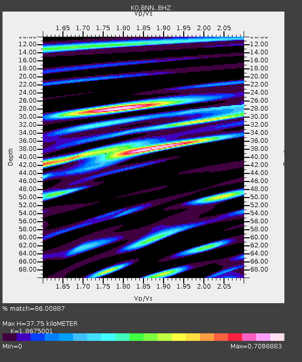
| Estimated Moho Depth: |
37.75 km |
| Estimated Crust Vp/Vs: |
1.87 |
| Assumed Crust Vp: |
6.35 km/s |
| Estimated Crust Vs: |
3.4 km/s |
| Estimated Crust Poisson's Ratio: |
0.30 |
|
| Radial Match: |
86.00887 % |
| Radial Bump: |
400 |
| Transverse Match: |
81.176384 % |
| Transverse Bump: |
400 |
| SOD ConfigId: |
13570011 |
| Insert Time: |
2019-04-29 15:35:20.259 +0000 |
| GWidth: |
2.5 |
| Max Bumps: |
400 |
| Tol: |
0.001 |
|

Signal To Noise
| Channel | StoN | STA | LTA |
| KO:BNN: :BHZ:20180124T11:02:32.499976Z | 20.862295 | 8.963468E-6 | 4.2964916E-7 |
| KO:BNN: :BHN:20180124T11:02:32.499976Z | 9.71016 | 2.8372424E-6 | 2.9219316E-7 |
| KO:BNN: :BHE:20180124T11:02:32.499976Z | 4.3350253 | 1.8629605E-6 | 4.2974617E-7 |
| Arrivals |
| Ps | 5.3 SECOND |
| PpPs | 17 SECOND |
| PsPs/PpSs | 22 SECOND |


