You are here: Home > Network List > KO - Kandilli Observatory Digital Broadband Seismic Network Stations List
> Station BNN Bunyan-Kayseri-Turkey > Earthquake Result Viewer
BNN Bunyan-Kayseri-Turkey - Earthquake Result Viewer
| Earthquake location: |
Komandorskiye Ostrova Region |
| Earthquake latitude/longitude: |
55.4/164.4 |
| Earthquake time(UTC): |
2018/12/24 (358) 12:41:19 GMT |
| Earthquake Depth: |
10 km |
| Earthquake Magnitude: |
6.1 Mww |
| Earthquake Catalog/Contributor: |
NEIC PDE/us |
|
| Network: |
KO Kandilli Observatory Digital Broadband Seismic Network |
| Station: |
BNN Bunyan-Kayseri-Turkey |
| Lat/Lon: |
38.85 N/35.85 E |
| Elevation: |
1380 m |
|
| Distance: |
76.4 deg |
| Az: |
321.097 deg |
| Baz: |
27.296 deg |
| Ray Param: |
0.05103655 |
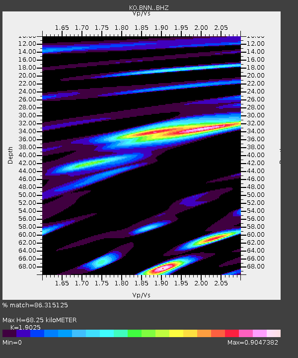
| Estimated Moho Depth: |
68.25 km |
| Estimated Crust Vp/Vs: |
1.90 |
| Assumed Crust Vp: |
6.35 km/s |
| Estimated Crust Vs: |
3.338 km/s |
| Estimated Crust Poisson's Ratio: |
0.31 |
|
| Radial Match: |
86.315125 % |
| Radial Bump: |
400 |
| Transverse Match: |
70.24948 % |
| Transverse Bump: |
400 |
| SOD ConfigId: |
13570011 |
| Insert Time: |
2019-05-02 04:28:09.199 +0000 |
| GWidth: |
2.5 |
| Max Bumps: |
400 |
| Tol: |
0.001 |
|

Signal To Noise
| Channel | StoN | STA | LTA |
| KO:BNN: :BHZ:20181224T12:52:37.220Z | 2.7969973 | 6.085863E-7 | 2.1758557E-7 |
| KO:BNN: :BHN:20181224T12:52:37.220Z | 2.518067 | 3.198786E-7 | 1.270334E-7 |
| KO:BNN: :BHE:20181224T12:52:37.220Z | 1.6318392 | 2.3698718E-7 | 1.4522705E-7 |
| Arrivals |
| Ps | 10.0 SECOND |
| PpPs | 30 SECOND |
| PsPs/PpSs | 40 SECOND |


