You are here: Home > Network List > KO - Kandilli Observatory Digital Broadband Seismic Network Stations List
> Station BNN Bunyan-Kayseri-Turkey > Earthquake Result Viewer
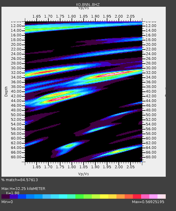
BNN Bunyan-Kayseri-Turkey - Earthquake Result Viewer
| Earthquake location: |
Rat Islands, Aleutian Islands |
| Earthquake latitude/longitude: |
52.2/178.1 |
| Earthquake time(UTC): |
2019/04/02 (092) 21:35:30 GMT |
| Earthquake Depth: |
6.5 km |
| Earthquake Magnitude: |
6.4 mww |
| Earthquake Catalog/Contributor: |
NEIC PDE/us |
|
| Network: |
KO Kandilli Observatory Digital Broadband Seismic Network |
| Station: |
BNN Bunyan-Kayseri-Turkey |
| Lat/Lon: |
38.85 N/35.85 E |
| Elevation: |
1380 m |
|
| Distance: |
83.6 deg |
| Az: |
331.227 deg |
| Baz: |
22.321 deg |
| Ray Param: |
0.04609586 |
| Estimated Moho Depth: |
32.25 km |
| Estimated Crust Vp/Vs: |
1.98 |
| Assumed Crust Vp: |
6.35 km/s |
| Estimated Crust Vs: |
3.207 km/s |
| Estimated Crust Poisson's Ratio: |
0.33 |
|
| Radial Match: |
84.57613 % |
| Radial Bump: |
400 |
| Transverse Match: |
83.171555 % |
| Transverse Bump: |
400 |
| SOD ConfigId: |
13570011 |
| Insert Time: |
2019-05-02 21:02:58.358 +0000 |
| GWidth: |
2.5 |
| Max Bumps: |
400 |
| Tol: |
0.001 |
|

Signal To Noise
| Channel | StoN | STA | LTA |
| KO:BNN: :BHZ:20190402T21:47:27.099971Z | 5.3407845 | 1.2718237E-6 | 2.3813426E-7 |
| KO:BNN: :BHN:20190402T21:47:27.099971Z | 1.5956181 | 3.2574886E-7 | 2.0415214E-7 |
| KO:BNN: :BHE:20190402T21:47:27.099971Z | 1.5727478 | 3.4273344E-7 | 2.1792015E-7 |
| Arrivals |
| Ps | 5.1 SECOND |
| PpPs | 15 SECOND |
| PsPs/PpSs | 20 SECOND |


