You are here: Home > Network List > KO - Kandilli Observatory Digital Broadband Seismic Network Stations List
> Station BNN Bunyan-Kayseri-Turkey > Earthquake Result Viewer
BNN Bunyan-Kayseri-Turkey - Earthquake Result Viewer
| Earthquake location: |
Halmahera, Indonesia |
| Earthquake latitude/longitude: |
-0.5/128.1 |
| Earthquake time(UTC): |
2019/07/14 (195) 09:10:50 GMT |
| Earthquake Depth: |
10 km |
| Earthquake Magnitude: |
7.3 Mww |
| Earthquake Catalog/Contributor: |
NEIC PDE/us |
|
| Network: |
KO Kandilli Observatory Digital Broadband Seismic Network |
| Station: |
BNN Bunyan-Kayseri-Turkey |
| Lat/Lon: |
38.85 N/35.85 E |
| Elevation: |
1380 m |
|
| Distance: |
92.1 deg |
| Az: |
308.672 deg |
| Baz: |
89.007 deg |
| Ray Param: |
0.041512154 |
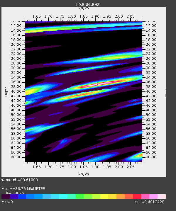
| Estimated Moho Depth: |
36.75 km |
| Estimated Crust Vp/Vs: |
1.91 |
| Assumed Crust Vp: |
6.35 km/s |
| Estimated Crust Vs: |
3.329 km/s |
| Estimated Crust Poisson's Ratio: |
0.31 |
|
| Radial Match: |
88.61003 % |
| Radial Bump: |
400 |
| Transverse Match: |
85.10561 % |
| Transverse Bump: |
400 |
| SOD ConfigId: |
19053131 |
| Insert Time: |
2019-07-28 09:13:21.290 +0000 |
| GWidth: |
2.5 |
| Max Bumps: |
400 |
| Tol: |
0.001 |
|

Signal To Noise
| Channel | StoN | STA | LTA |
| KO:BNN: :BHZ:20190714T09:23:28.179973Z | 8.153406 | 1.2020646E-6 | 1.4743098E-7 |
| KO:BNN: :BHN:20190714T09:23:28.179973Z | 1.5585914 | 2.1475239E-7 | 1.3778622E-7 |
| KO:BNN: :BHE:20190714T09:23:28.179973Z | 2.6996825 | 3.3247792E-7 | 1.2315445E-7 |
| Arrivals |
| Ps | 5.4 SECOND |
| PpPs | 17 SECOND |
| PsPs/PpSs | 22 SECOND |


