You are here: Home > Network List > KO - Kandilli Observatory Digital Broadband Seismic Network Stations List
> Station BNN Bunyan-Kayseri-Turkey > Earthquake Result Viewer
BNN Bunyan-Kayseri-Turkey - Earthquake Result Viewer
| Earthquake location: |
Halmahera, Indonesia |
| Earthquake latitude/longitude: |
2.9/128.2 |
| Earthquake time(UTC): |
2020/06/04 (156) 08:49:41 GMT |
| Earthquake Depth: |
127 km |
| Earthquake Magnitude: |
6.7 Mi |
| Earthquake Catalog/Contributor: |
NEIC PDE/at |
|
| Network: |
KO Kandilli Observatory Digital Broadband Seismic Network |
| Station: |
BNN Bunyan-Kayseri-Turkey |
| Lat/Lon: |
38.85 N/35.85 E |
| Elevation: |
1380 m |
|
| Distance: |
90.1 deg |
| Az: |
308.726 deg |
| Baz: |
86.259 deg |
| Ray Param: |
0.041704718 |
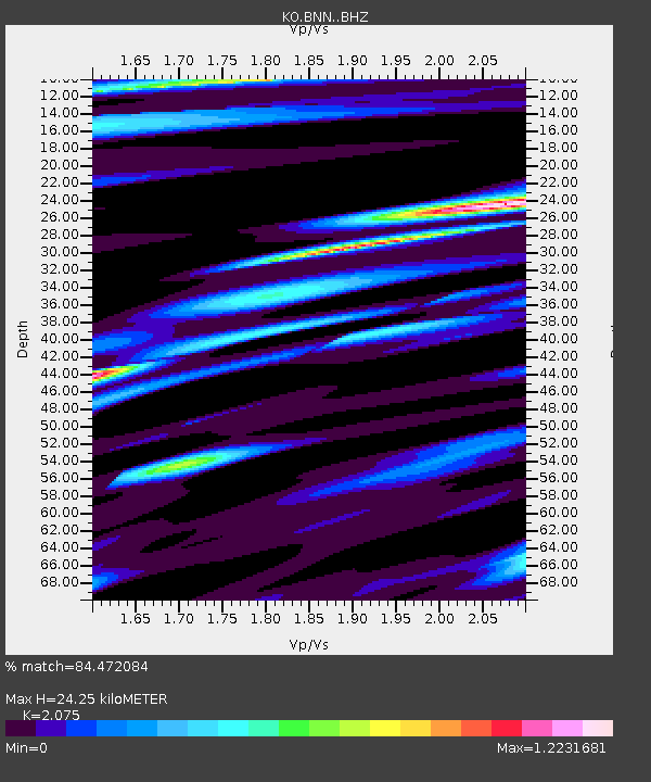
| Estimated Moho Depth: |
24.25 km |
| Estimated Crust Vp/Vs: |
2.08 |
| Assumed Crust Vp: |
6.35 km/s |
| Estimated Crust Vs: |
3.06 km/s |
| Estimated Crust Poisson's Ratio: |
0.35 |
|
| Radial Match: |
84.472084 % |
| Radial Bump: |
400 |
| Transverse Match: |
78.065926 % |
| Transverse Bump: |
400 |
| SOD ConfigId: |
21166931 |
| Insert Time: |
2020-06-18 08:59:30.644 +0000 |
| GWidth: |
2.5 |
| Max Bumps: |
400 |
| Tol: |
0.001 |
|

Signal To Noise
| Channel | StoN | STA | LTA |
| KO:BNN: :BHZ:20200604T09:01:55.200012Z | 38.013702 | 4.5960915E-6 | 1.2090618E-7 |
| KO:BNN: :BHN:20200604T09:01:55.200012Z | 4.189701 | 6.836166E-7 | 1.6316594E-7 |
| KO:BNN: :BHE:20200604T09:01:55.200012Z | 6.452205 | 1.0929522E-6 | 1.6939204E-7 |
| Arrivals |
| Ps | 4.2 SECOND |
| PpPs | 12 SECOND |
| PsPs/PpSs | 16 SECOND |


