You are here: Home > Network List > KO - Kandilli Observatory Digital Broadband Seismic Network Stations List
> Station BNN Bunyan-Kayseri-Turkey > Earthquake Result Viewer
BNN Bunyan-Kayseri-Turkey - Earthquake Result Viewer
| Earthquake location: |
Tanzania |
| Earthquake latitude/longitude: |
-7.3/39.8 |
| Earthquake time(UTC): |
2020/08/12 (225) 17:13:15 GMT |
| Earthquake Depth: |
12 km |
| Earthquake Magnitude: |
5.9 mww |
| Earthquake Catalog/Contributor: |
NEIC PDE/us |
|
| Network: |
KO Kandilli Observatory Digital Broadband Seismic Network |
| Station: |
BNN Bunyan-Kayseri-Turkey |
| Lat/Lon: |
38.85 N/35.85 E |
| Elevation: |
1380 m |
|
| Distance: |
46.1 deg |
| Az: |
355.704 deg |
| Baz: |
174.539 deg |
| Ray Param: |
0.07087001 |
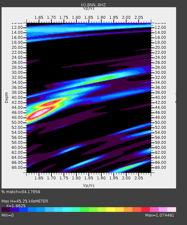
| Estimated Moho Depth: |
45.25 km |
| Estimated Crust Vp/Vs: |
1.66 |
| Assumed Crust Vp: |
6.35 km/s |
| Estimated Crust Vs: |
3.82 km/s |
| Estimated Crust Poisson's Ratio: |
0.22 |
|
| Radial Match: |
84.17956 % |
| Radial Bump: |
400 |
| Transverse Match: |
79.46556 % |
| Transverse Bump: |
400 |
| SOD ConfigId: |
21709731 |
| Insert Time: |
2020-08-26 17:18:14.750 +0000 |
| GWidth: |
2.5 |
| Max Bumps: |
400 |
| Tol: |
0.001 |
|

Signal To Noise
| Channel | StoN | STA | LTA |
| KO:BNN: :BHZ:20200812T17:21:08.199991Z | 14.669638 | 2.3284085E-6 | 1.5872298E-7 |
| KO:BNN: :BHN:20200812T17:21:08.199991Z | 8.672301 | 1.1260048E-6 | 1.2983922E-7 |
| KO:BNN: :BHE:20200812T17:21:08.199991Z | 4.240904 | 5.203824E-7 | 1.2270554E-7 |
| Arrivals |
| Ps | 5.0 SECOND |
| PpPs | 18 SECOND |
| PsPs/PpSs | 23 SECOND |


