You are here: Home > Network List > KO - Kandilli Observatory Digital Broadband Seismic Network Stations List
> Station BNN Bunyan-Kayseri-Turkey > Earthquake Result Viewer
BNN Bunyan-Kayseri-Turkey - Earthquake Result Viewer
| Earthquake location: |
Chagos Archipelago Region |
| Earthquake latitude/longitude: |
-4.1/70.3 |
| Earthquake time(UTC): |
2020/08/31 (244) 17:24:04 GMT |
| Earthquake Depth: |
10 km |
| Earthquake Magnitude: |
6.2 mww |
| Earthquake Catalog/Contributor: |
NEIC PDE/us |
|
| Network: |
KO Kandilli Observatory Digital Broadband Seismic Network |
| Station: |
BNN Bunyan-Kayseri-Turkey |
| Lat/Lon: |
38.85 N/35.85 E |
| Elevation: |
1380 m |
|
| Distance: |
53.2 deg |
| Az: |
326.581 deg |
| Baz: |
135.284 deg |
| Ray Param: |
0.06625263 |
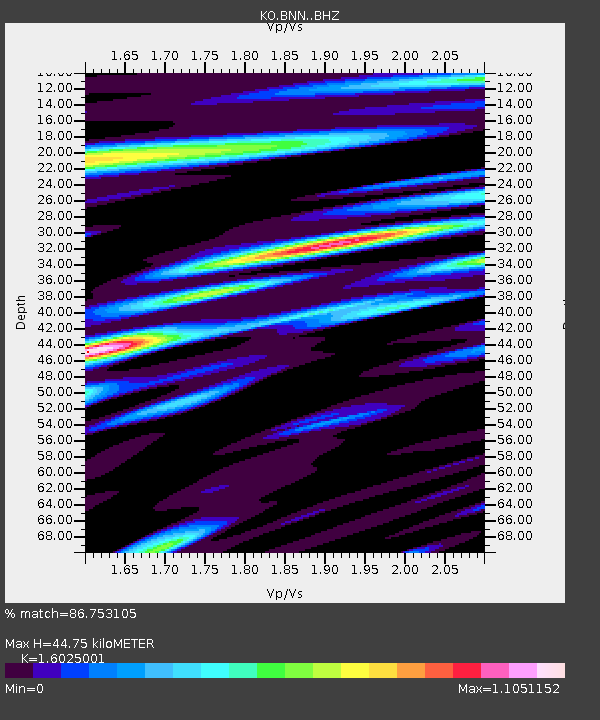
| Estimated Moho Depth: |
44.75 km |
| Estimated Crust Vp/Vs: |
1.60 |
| Assumed Crust Vp: |
6.35 km/s |
| Estimated Crust Vs: |
3.963 km/s |
| Estimated Crust Poisson's Ratio: |
0.18 |
|
| Radial Match: |
86.753105 % |
| Radial Bump: |
400 |
| Transverse Match: |
65.165855 % |
| Transverse Bump: |
400 |
| SOD ConfigId: |
21709731 |
| Insert Time: |
2020-09-14 17:28:51.495 +0000 |
| GWidth: |
2.5 |
| Max Bumps: |
400 |
| Tol: |
0.001 |
|

Signal To Noise
| Channel | StoN | STA | LTA |
| KO:BNN: :BHZ:20200831T17:32:52.099995Z | 12.982228 | 1.92691E-6 | 1.4842676E-7 |
| KO:BNN: :BHN:20200831T17:32:52.099995Z | 2.703264 | 5.1777783E-7 | 1.9153802E-7 |
| KO:BNN: :BHE:20200831T17:32:52.099995Z | 5.4421725 | 7.2781074E-7 | 1.3373533E-7 |
| Arrivals |
| Ps | 4.5 SECOND |
| PpPs | 17 SECOND |
| PsPs/PpSs | 22 SECOND |


