You are here: Home > Network List > KO - Kandilli Observatory Digital Broadband Seismic Network Stations List
> Station BNN Bunyan-Kayseri-Turkey > Earthquake Result Viewer
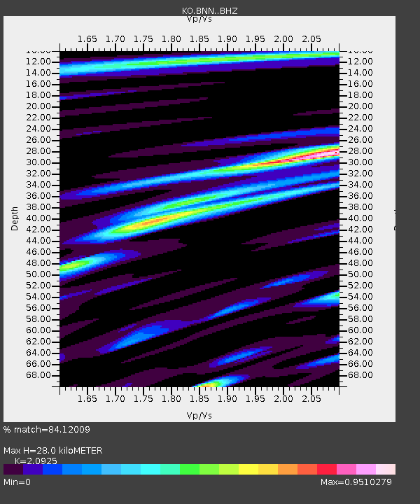
BNN Bunyan-Kayseri-Turkey - Earthquake Result Viewer
| Earthquake location: |
Kuril Islands |
| Earthquake latitude/longitude: |
44.0/147.9 |
| Earthquake time(UTC): |
2021/03/02 (061) 21:22:45 GMT |
| Earthquake Depth: |
28 km |
| Earthquake Magnitude: |
5.8 mww |
| Earthquake Catalog/Contributor: |
NEIC PDE/us |
|
| Network: |
KO Kandilli Observatory Digital Broadband Seismic Network |
| Station: |
BNN Bunyan-Kayseri-Turkey |
| Lat/Lon: |
38.85 N/35.85 E |
| Elevation: |
1380 m |
|
| Distance: |
77.2 deg |
| Az: |
312.083 deg |
| Baz: |
43.346 deg |
| Ray Param: |
0.050418776 |
| Estimated Moho Depth: |
28.0 km |
| Estimated Crust Vp/Vs: |
2.09 |
| Assumed Crust Vp: |
6.35 km/s |
| Estimated Crust Vs: |
3.035 km/s |
| Estimated Crust Poisson's Ratio: |
0.35 |
|
| Radial Match: |
84.12009 % |
| Radial Bump: |
400 |
| Transverse Match: |
78.13869 % |
| Transverse Bump: |
400 |
| SOD ConfigId: |
23341671 |
| Insert Time: |
2021-03-16 22:37:04.545 +0000 |
| GWidth: |
2.5 |
| Max Bumps: |
400 |
| Tol: |
0.001 |
|

Signal To Noise
| Channel | StoN | STA | LTA |
| KO:BNN: :BHZ:20210302T21:34:05.859987Z | 13.28998 | 3.0105748E-6 | 2.2652966E-7 |
| KO:BNN: :BHN:20210302T21:34:05.859987Z | 4.656704 | 8.336155E-7 | 1.7901407E-7 |
| KO:BNN: :BHE:20210302T21:34:05.859987Z | 3.3668451 | 7.3545993E-7 | 2.1844187E-7 |
| Arrivals |
| Ps | 4.9 SECOND |
| PpPs | 13 SECOND |
| PsPs/PpSs | 18 SECOND |


