You are here: Home > Network List > KO - Kandilli Observatory Digital Broadband Seismic Network Stations List
> Station BNN Bunyan-Kayseri-Turkey > Earthquake Result Viewer
BNN Bunyan-Kayseri-Turkey - Earthquake Result Viewer
| Earthquake location: |
Kuril Islands |
| Earthquake latitude/longitude: |
48.8/155.0 |
| Earthquake time(UTC): |
2021/08/24 (236) 05:37:51 GMT |
| Earthquake Depth: |
31 km |
| Earthquake Magnitude: |
6.0 mww |
| Earthquake Catalog/Contributor: |
NEIC PDE/us |
|
| Network: |
KO Kandilli Observatory Digital Broadband Seismic Network |
| Station: |
BNN Bunyan-Kayseri-Turkey |
| Lat/Lon: |
38.85 N/35.85 E |
| Elevation: |
1380 m |
|
| Distance: |
77.4 deg |
| Az: |
315.655 deg |
| Baz: |
36.278 deg |
| Ray Param: |
0.050296817 |
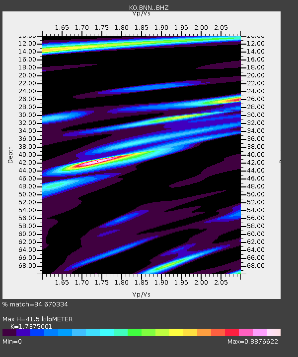
| Estimated Moho Depth: |
41.5 km |
| Estimated Crust Vp/Vs: |
1.74 |
| Assumed Crust Vp: |
6.35 km/s |
| Estimated Crust Vs: |
3.655 km/s |
| Estimated Crust Poisson's Ratio: |
0.25 |
|
| Radial Match: |
84.670334 % |
| Radial Bump: |
400 |
| Transverse Match: |
83.50738 % |
| Transverse Bump: |
400 |
| SOD ConfigId: |
25131211 |
| Insert Time: |
2021-09-07 05:55:35.244 +0000 |
| GWidth: |
2.5 |
| Max Bumps: |
400 |
| Tol: |
0.001 |
|

Signal To Noise
| Channel | StoN | STA | LTA |
| KO:BNN: :BHZ:20210824T05:49:12.220001Z | 17.849499 | 2.6838259E-6 | 1.5035862E-7 |
| KO:BNN: :BHN:20210824T05:49:12.220001Z | 6.18722 | 9.671745E-7 | 1.5631811E-7 |
| KO:BNN: :BHE:20210824T05:49:12.220001Z | 3.0339103 | 4.1518425E-7 | 1.368479E-7 |
| Arrivals |
| Ps | 5.0 SECOND |
| PpPs | 17 SECOND |
| PsPs/PpSs | 22 SECOND |


