You are here: Home > Network List > KO - Kandilli Observatory Digital Broadband Seismic Network Stations List
> Station BNN Bunyan-Kayseri-Turkey > Earthquake Result Viewer
BNN Bunyan-Kayseri-Turkey - Earthquake Result Viewer
| Earthquake location: |
Jan Mayen Island Region |
| Earthquake latitude/longitude: |
70.7/-14.4 |
| Earthquake time(UTC): |
2022/02/14 (045) 20:28:21 GMT |
| Earthquake Depth: |
10 km |
| Earthquake Magnitude: |
5.7 Mww |
| Earthquake Catalog/Contributor: |
NEIC PDE/us |
|
| Network: |
KO Kandilli Observatory Digital Broadband Seismic Network |
| Station: |
BNN Bunyan-Kayseri-Turkey |
| Lat/Lon: |
38.85 N/35.85 E |
| Elevation: |
1380 m |
|
| Distance: |
41.0 deg |
| Az: |
113.749 deg |
| Baz: |
337.099 deg |
| Ray Param: |
0.07409291 |
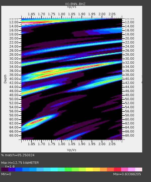
| Estimated Moho Depth: |
12.75 km |
| Estimated Crust Vp/Vs: |
1.60 |
| Assumed Crust Vp: |
6.35 km/s |
| Estimated Crust Vs: |
3.969 km/s |
| Estimated Crust Poisson's Ratio: |
0.18 |
|
| Radial Match: |
85.250824 % |
| Radial Bump: |
396 |
| Transverse Match: |
67.08833 % |
| Transverse Bump: |
400 |
| SOD ConfigId: |
26694651 |
| Insert Time: |
2022-02-28 20:44:50.248 +0000 |
| GWidth: |
2.5 |
| Max Bumps: |
400 |
| Tol: |
0.001 |
|

Signal To Noise
| Channel | StoN | STA | LTA |
| KO:BNN: :BHZ:20220214T20:35:33.079997Z | 5.869731 | 1.243809E-6 | 2.119022E-7 |
| KO:BNN: :BHN:20220214T20:35:33.079997Z | 2.7648845 | 4.5352215E-7 | 1.6402933E-7 |
| KO:BNN: :BHE:20220214T20:35:33.079997Z | 1.8058208 | 3.2587292E-7 | 1.8045695E-7 |
| Arrivals |
| Ps | 1.3 SECOND |
| PpPs | 4.8 SECOND |
| PsPs/PpSs | 6.1 SECOND |


