You are here: Home > Network List > KO - Kandilli Observatory Digital Broadband Seismic Network Stations List
> Station BNN Bunyan-Kayseri-Turkey > Earthquake Result Viewer
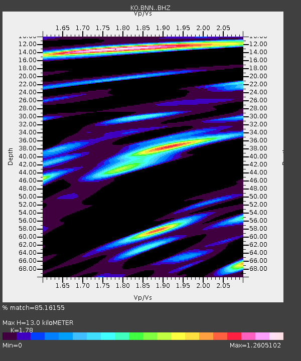
BNN Bunyan-Kayseri-Turkey - Earthquake Result Viewer
| Earthquake location: |
Northern Sumatra, Indonesia |
| Earthquake latitude/longitude: |
2.1/98.9 |
| Earthquake time(UTC): |
2022/09/30 (273) 19:28:39 GMT |
| Earthquake Depth: |
13 km |
| Earthquake Magnitude: |
5.9 Mww |
| Earthquake Catalog/Contributor: |
NEIC PDE/us |
|
| Network: |
KO Kandilli Observatory Digital Broadband Seismic Network |
| Station: |
BNN Bunyan-Kayseri-Turkey |
| Lat/Lon: |
38.85 N/35.85 E |
| Elevation: |
1380 m |
|
| Distance: |
67.9 deg |
| Az: |
311.303 deg |
| Baz: |
105.955 deg |
| Ray Param: |
0.056657307 |
| Estimated Moho Depth: |
13.0 km |
| Estimated Crust Vp/Vs: |
1.78 |
| Assumed Crust Vp: |
6.35 km/s |
| Estimated Crust Vs: |
3.567 km/s |
| Estimated Crust Poisson's Ratio: |
0.27 |
|
| Radial Match: |
85.16155 % |
| Radial Bump: |
400 |
| Transverse Match: |
73.860535 % |
| Transverse Bump: |
400 |
| SOD ConfigId: |
28764291 |
| Insert Time: |
2022-10-14 19:37:05.467 +0000 |
| GWidth: |
2.5 |
| Max Bumps: |
400 |
| Tol: |
0.001 |
|

Signal To Noise
| Channel | StoN | STA | LTA |
| KO:BNN: :BHZ:20220930T19:39:05.960014Z | 4.019361 | 5.132075E-7 | 1.2768386E-7 |
| KO:BNN: :BHN:20220930T19:39:05.960014Z | 1.0230112 | 1.3067518E-7 | 1.2773582E-7 |
| KO:BNN: :BHE:20220930T19:39:05.960014Z | 0.94620764 | 1.2513044E-7 | 1.3224417E-7 |
| Arrivals |
| Ps | 1.7 SECOND |
| PpPs | 5.5 SECOND |
| PsPs/PpSs | 7.1 SECOND |


