You are here: Home > Network List > KO - Kandilli Observatory Digital Broadband Seismic Network Stations List
> Station BNN Bunyan-Kayseri-Turkey > Earthquake Result Viewer
BNN Bunyan-Kayseri-Turkey - Earthquake Result Viewer
| Earthquake location: |
Leyte, Philippines |
| Earthquake latitude/longitude: |
10.2/125.9 |
| Earthquake time(UTC): |
2015/07/03 (184) 06:43:23 GMT |
| Earthquake Depth: |
50 km |
| Earthquake Magnitude: |
6.0 MB |
| Earthquake Catalog/Contributor: |
NEIC PDE/NEIC ALERT |
|
| Network: |
KO Kandilli Observatory Digital Broadband Seismic Network |
| Station: |
BNN Bunyan-Kayseri-Turkey |
| Lat/Lon: |
38.85 N/35.85 E |
| Elevation: |
1380 m |
|
| Distance: |
83.8 deg |
| Az: |
308.239 deg |
| Baz: |
82.03 deg |
| Ray Param: |
0.045854103 |
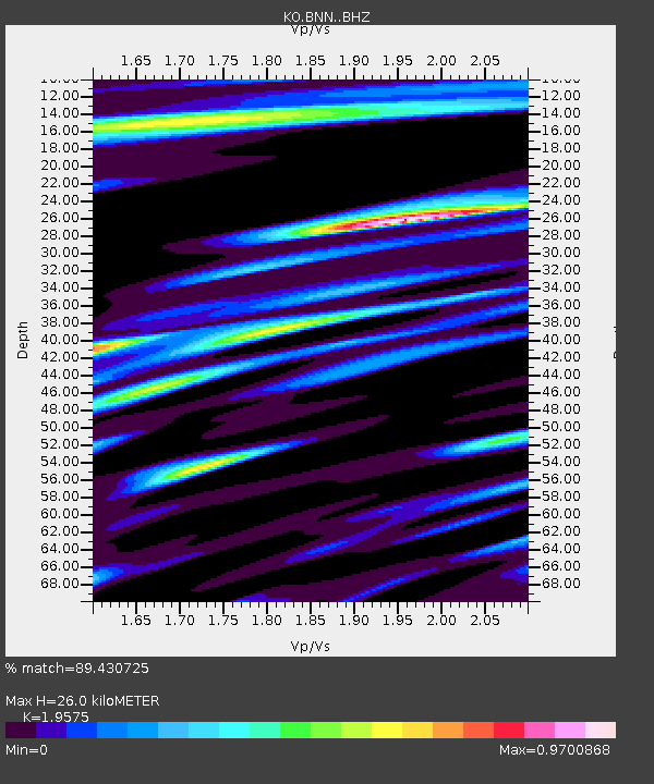
| Estimated Moho Depth: |
26.0 km |
| Estimated Crust Vp/Vs: |
1.96 |
| Assumed Crust Vp: |
6.35 km/s |
| Estimated Crust Vs: |
3.244 km/s |
| Estimated Crust Poisson's Ratio: |
0.32 |
|
| Radial Match: |
89.430725 % |
| Radial Bump: |
400 |
| Transverse Match: |
77.86049 % |
| Transverse Bump: |
400 |
| SOD ConfigId: |
7422571 |
| Insert Time: |
2019-04-19 14:58:35.793 +0000 |
| GWidth: |
2.5 |
| Max Bumps: |
400 |
| Tol: |
0.001 |
|

Signal To Noise
| Channel | StoN | STA | LTA |
| KO:BNN: :BHZ:20150703T06:55:15.760022Z | 30.548279 | 4.420519E-6 | 1.44706E-7 |
| KO:BNN: :BHN:20150703T06:55:15.760022Z | 6.32823 | 7.144181E-7 | 1.1289383E-7 |
| KO:BNN: :BHE:20150703T06:55:15.760022Z | 13.769984 | 1.191501E-6 | 8.6528864E-8 |
| Arrivals |
| Ps | 4.0 SECOND |
| PpPs | 12 SECOND |
| PsPs/PpSs | 16 SECOND |


