You are here: Home > Network List > KO - Kandilli Observatory Digital Broadband Seismic Network Stations List
> Station BNN Bunyan-Kayseri-Turkey > Earthquake Result Viewer
BNN Bunyan-Kayseri-Turkey - Earthquake Result Viewer
| Earthquake location: |
South Of Java, Indonesia |
| Earthquake latitude/longitude: |
-9.2/112.7 |
| Earthquake time(UTC): |
2015/07/26 (207) 07:05:08 GMT |
| Earthquake Depth: |
59 km |
| Earthquake Magnitude: |
6.0 MWP |
| Earthquake Catalog/Contributor: |
NEIC PDE/NEIC COMCAT |
|
| Network: |
KO Kandilli Observatory Digital Broadband Seismic Network |
| Station: |
BNN Bunyan-Kayseri-Turkey |
| Lat/Lon: |
38.85 N/35.85 E |
| Elevation: |
1380 m |
|
| Distance: |
85.7 deg |
| Az: |
310.313 deg |
| Baz: |
105.412 deg |
| Ray Param: |
0.04449724 |
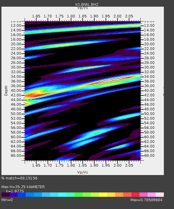
| Estimated Moho Depth: |
35.25 km |
| Estimated Crust Vp/Vs: |
1.98 |
| Assumed Crust Vp: |
6.35 km/s |
| Estimated Crust Vs: |
3.211 km/s |
| Estimated Crust Poisson's Ratio: |
0.33 |
|
| Radial Match: |
88.15156 % |
| Radial Bump: |
400 |
| Transverse Match: |
78.697556 % |
| Transverse Bump: |
400 |
| SOD ConfigId: |
7422571 |
| Insert Time: |
2019-04-19 23:01:52.138 +0000 |
| GWidth: |
2.5 |
| Max Bumps: |
400 |
| Tol: |
0.001 |
|

Signal To Noise
| Channel | StoN | STA | LTA |
| KO:BNN: :BHZ:20150726T07:17:09.120015Z | 21.930151 | 2.8747845E-6 | 1.3108821E-7 |
| KO:BNN: :BHN:20150726T07:17:09.120015Z | 1.0671592 | 1.6931347E-7 | 1.5865811E-7 |
| KO:BNN: :BHE:20150726T07:17:09.120015Z | 5.094099 | 8.2334464E-7 | 1.6162714E-7 |
| Arrivals |
| Ps | 5.5 SECOND |
| PpPs | 16 SECOND |
| PsPs/PpSs | 22 SECOND |


