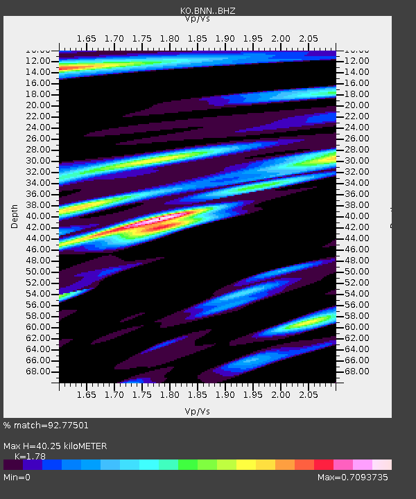
BNN Bunyan-Kayseri-Turkey - Earthquake Result Viewer

Earthquake location: Southern Alaska
Earthquake latitude/longitude: 59.9/-153.1
Earthquake time(UTC): 2015/07/29 (210) 02:35:58 GMT
Earthquake Depth: 118 km
Earthquake Magnitude: 6.3 ML, 6.2 MWP, 6.2 MI, 6.3 MWW
Earthquake Catalog/Contributor: NEIC PDE/NEIC COMCAT
Network: KO Kandilli Observatory Digital Broadband Seismic Network
Station: BNN Bunyan-Kayseri-Turkey
Lat/Lon: 38.85 N/35.85 E
Elevation: 1380 m
Distance: 81.3 deg
Az: 352.966 deg
Baz: 4.534 deg
Ray Param: 0.047391146
Estimated Moho Depth: 40.25 km
Estimated Crust Vp/Vs: 1.78
Assumed Crust Vp: 6.35 km/s
Estimated Crust Vs: 3.567 km/s
Estimated Crust Poisson's Ratio: 0.27
Radial Match: 92.77501 %
Radial Bump: 400
Transverse Match: 89.49547 %
Transverse Bump: 400
SOD ConfigId: 7422571
Insert Time: 2019-04-20 01:45:10.950 +0000
GWidth: 2.5
Max Bumps: 400
Tol: 0.001

Signal To Noise

ChannelStoNSTALTA
KO:BNN: :BHZ:20150729T02:47:29.580017Z22.4890582.7955664E-61.2430785E-7
KO:BNN: :BHN:20150729T02:47:29.580017Z11.40747451.1033228E-69.671928E-8
KO:BNN: :BHE:20150729T02:47:29.580017Z2.67549473.4722018E-71.2977794E-7
Arrivals
Ps5.1 SECOND
PpPs17 SECOND
PsPs/PpSs22 SECOND