You are here: Home > Network List > IU - Global Seismograph Network (GSN - IRIS/USGS) Stations List
> Station COR Corvallis, Oregon, USA > Earthquake Result Viewer
COR Corvallis, Oregon, USA - Earthquake Result Viewer
| Earthquake location: |
Peru-Brazil Border Region |
| Earthquake latitude/longitude: |
-11.0/-70.8 |
| Earthquake time(UTC): |
1990/10/17 (290) 14:30:14 GMT |
| Earthquake Depth: |
624 km |
| Earthquake Magnitude: |
6.7 MB, 6.8 UNKNOWN |
| Earthquake Catalog/Contributor: |
WHDF/NEIC |
|
| Network: |
IU Global Seismograph Network (GSN - IRIS/USGS) |
| Station: |
COR Corvallis, Oregon, USA |
| Lat/Lon: |
44.59 N/123.30 W |
| Elevation: |
121 m |
|
| Distance: |
72.9 deg |
| Az: |
323.604 deg |
| Baz: |
125.377 deg |
| Ray Param: |
0.05124815 |
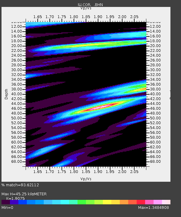
| Estimated Moho Depth: |
45.25 km |
| Estimated Crust Vp/Vs: |
1.91 |
| Assumed Crust Vp: |
6.566 km/s |
| Estimated Crust Vs: |
3.442 km/s |
| Estimated Crust Poisson's Ratio: |
0.31 |
|
| Radial Match: |
93.62112 % |
| Radial Bump: |
400 |
| Transverse Match: |
82.4278 % |
| Transverse Bump: |
400 |
| SOD ConfigId: |
16938 |
| Insert Time: |
2010-03-04 20:03:47.669 +0000 |
| GWidth: |
2.5 |
| Max Bumps: |
400 |
| Tol: |
0.001 |
|

Signal To Noise
| Channel | StoN | STA | LTA |
| IU:COR: :BHN:19901017T14:40:11.215002Z | 5.580558 | 2.3240723E-6 | 4.164588E-7 |
| IU:COR: :BHE:19901017T14:40:11.212012Z | 6.1275973 | 4.1490443E-6 | 6.771079E-7 |
| IU:COR: :BHZ:19901017T14:40:11.212012Z | 45.78801 | 1.7560835E-5 | 3.8352474E-7 |
| Arrivals |
| Ps | 6.4 SECOND |
| PpPs | 19 SECOND |
| PsPs/PpSs | 26 SECOND |


