You are here: Home > Network List > YB13 - Continental Dynamics/Cent. Anatolian Tectonics:Surface to Mantle Dynamics During Stations List
> Station AT49 Kolukisa,Konya,Turkey > Earthquake Result Viewer
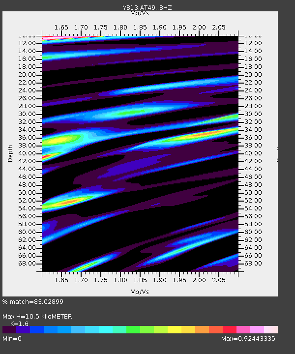
AT49 Kolukisa,Konya,Turkey - Earthquake Result Viewer
| Earthquake location: |
Xizang |
| Earthquake latitude/longitude: |
35.9/82.6 |
| Earthquake time(UTC): |
2014/02/12 (043) 09:19:49 GMT |
| Earthquake Depth: |
10 km |
| Earthquake Magnitude: |
6.9 MWW, 6.9 MWB, 6.9 MWC |
| Earthquake Catalog/Contributor: |
NEIC PDE/NEIC COMCAT |
|
| Network: |
YB Continental Dynamics/Cent. Anatolian Tectonics:Surface to Mantle Dynamics During |
| Station: |
AT49 Kolukisa,Konya,Turkey |
| Lat/Lon: |
38.51 N/32.25 E |
| Elevation: |
1036 m |
|
| Distance: |
39.8 deg |
| Az: |
289.267 deg |
| Baz: |
77.664 deg |
| Ray Param: |
0.07479145 |
| Estimated Moho Depth: |
10.5 km |
| Estimated Crust Vp/Vs: |
1.60 |
| Assumed Crust Vp: |
6.159 km/s |
| Estimated Crust Vs: |
3.849 km/s |
| Estimated Crust Poisson's Ratio: |
0.18 |
|
| Radial Match: |
83.02899 % |
| Radial Bump: |
332 |
| Transverse Match: |
72.692955 % |
| Transverse Bump: |
271 |
| SOD ConfigId: |
3390531 |
| Insert Time: |
2019-04-10 08:02:06.650 +0000 |
| GWidth: |
2.5 |
| Max Bumps: |
400 |
| Tol: |
0.001 |
|

Signal To Noise
| Channel | StoN | STA | LTA |
| YB:AT49: :BHZ:20140212T09:26:51.440005Z | 12.892766 | 1.1858168E-6 | 9.1975366E-8 |
| YB:AT49: :BHN:20140212T09:26:51.440005Z | 2.6012387 | 1.9289911E-7 | 7.415663E-8 |
| YB:AT49: :BHE:20140212T09:26:51.440005Z | 3.4239001 | 3.1702237E-7 | 9.259101E-8 |
| Arrivals |
| Ps | 1.1 SECOND |
| PpPs | 4.1 SECOND |
| PsPs/PpSs | 5.2 SECOND |


