You are here: Home > Network List > YB13 - Continental Dynamics/Cent. Anatolian Tectonics:Surface to Mantle Dynamics During Stations List
> Station AT49 Kolukisa,Konya,Turkey > Earthquake Result Viewer
AT49 Kolukisa,Konya,Turkey - Earthquake Result Viewer
| Earthquake location: |
North Atlantic Ocean |
| Earthquake latitude/longitude: |
14.7/-58.9 |
| Earthquake time(UTC): |
2014/02/18 (049) 09:27:13 GMT |
| Earthquake Depth: |
17 km |
| Earthquake Magnitude: |
6.5 MWW, 6.3 MWB, 6.5 MWC, 6.6 MWC, 6.7 MI |
| Earthquake Catalog/Contributor: |
NEIC PDE/NEIC COMCAT |
|
| Network: |
YB Continental Dynamics/Cent. Anatolian Tectonics:Surface to Mantle Dynamics During |
| Station: |
AT49 Kolukisa,Konya,Turkey |
| Lat/Lon: |
38.51 N/32.25 E |
| Elevation: |
1036 m |
|
| Distance: |
81.9 deg |
| Az: |
52.387 deg |
| Baz: |
282.219 deg |
| Ray Param: |
0.047221113 |
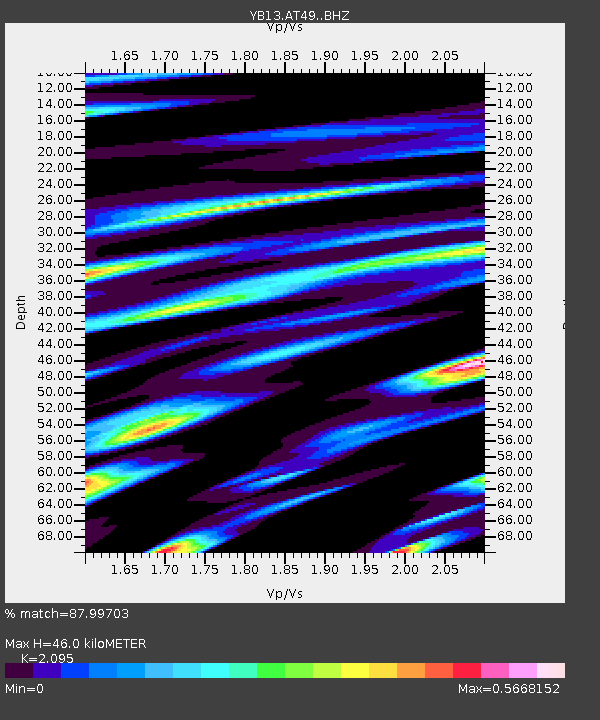
| Estimated Moho Depth: |
46.0 km |
| Estimated Crust Vp/Vs: |
2.10 |
| Assumed Crust Vp: |
6.159 km/s |
| Estimated Crust Vs: |
2.94 km/s |
| Estimated Crust Poisson's Ratio: |
0.35 |
|
| Radial Match: |
87.99703 % |
| Radial Bump: |
400 |
| Transverse Match: |
85.16582 % |
| Transverse Bump: |
400 |
| SOD ConfigId: |
3390531 |
| Insert Time: |
2019-04-10 09:16:17.924 +0000 |
| GWidth: |
2.5 |
| Max Bumps: |
400 |
| Tol: |
0.001 |
|

Signal To Noise
| Channel | StoN | STA | LTA |
| YB:AT49: :BHZ:20140218T09:39:00.920007Z | 27.957489 | 2.1996107E-6 | 7.8676976E-8 |
| YB:AT49: :BHN:20140218T09:39:00.920007Z | 2.7405777 | 1.980912E-7 | 7.228082E-8 |
| YB:AT49: :BHE:20140218T09:39:00.920007Z | 8.83394 | 6.9478807E-7 | 7.8649855E-8 |
| Arrivals |
| Ps | 8.4 SECOND |
| PpPs | 23 SECOND |
| PsPs/PpSs | 31 SECOND |


