You are here: Home > Network List > YB13 - Continental Dynamics/Cent. Anatolian Tectonics:Surface to Mantle Dynamics During Stations List
> Station AT49 Kolukisa,Konya,Turkey > Earthquake Result Viewer
AT49 Kolukisa,Konya,Turkey - Earthquake Result Viewer
| Earthquake location: |
Kyushu, Japan |
| Earthquake latitude/longitude: |
33.7/131.8 |
| Earthquake time(UTC): |
2014/03/13 (072) 17:06:50 GMT |
| Earthquake Depth: |
79 km |
| Earthquake Magnitude: |
6.3 MWW, 6.3 MWB, 6.3 MWC |
| Earthquake Catalog/Contributor: |
NEIC PDE/NEIC COMCAT |
|
| Network: |
YB Continental Dynamics/Cent. Anatolian Tectonics:Surface to Mantle Dynamics During |
| Station: |
AT49 Kolukisa,Konya,Turkey |
| Lat/Lon: |
38.51 N/32.25 E |
| Elevation: |
1036 m |
|
| Distance: |
76.5 deg |
| Az: |
307.29 deg |
| Baz: |
57.736 deg |
| Ray Param: |
0.050785445 |
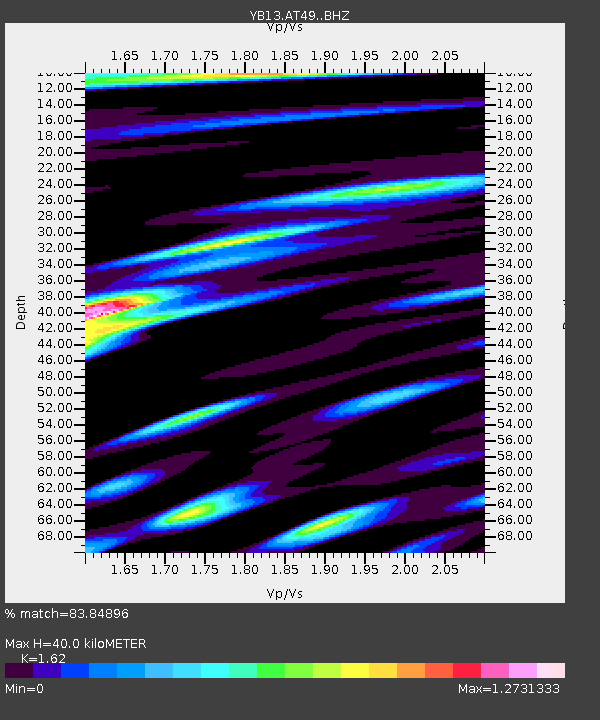
| Estimated Moho Depth: |
40.0 km |
| Estimated Crust Vp/Vs: |
1.62 |
| Assumed Crust Vp: |
6.159 km/s |
| Estimated Crust Vs: |
3.802 km/s |
| Estimated Crust Poisson's Ratio: |
0.19 |
|
| Radial Match: |
83.84896 % |
| Radial Bump: |
400 |
| Transverse Match: |
78.7608 % |
| Transverse Bump: |
400 |
| SOD ConfigId: |
3390531 |
| Insert Time: |
2019-04-10 15:37:45.603 +0000 |
| GWidth: |
2.5 |
| Max Bumps: |
400 |
| Tol: |
0.001 |
|

Signal To Noise
| Channel | StoN | STA | LTA |
| YB:AT49: :BHZ:20140313T17:18:01.059001Z | 10.184861 | 1.0629616E-6 | 1.0436682E-7 |
| YB:AT49: :BHN:20140313T17:18:01.059001Z | 2.6552942 | 3.1961227E-7 | 1.2036794E-7 |
| YB:AT49: :BHE:20140313T17:18:01.059001Z | 1.5927294 | 2.4400197E-7 | 1.5319738E-7 |
| Arrivals |
| Ps | 4.2 SECOND |
| PpPs | 16 SECOND |
| PsPs/PpSs | 21 SECOND |


