You are here: Home > Network List > YB13 - Continental Dynamics/Cent. Anatolian Tectonics:Surface to Mantle Dynamics During Stations List
> Station AT49 Kolukisa,Konya,Turkey > Earthquake Result Viewer
AT49 Kolukisa,Konya,Turkey - Earthquake Result Viewer
| Earthquake location: |
Taiwan Region |
| Earthquake latitude/longitude: |
24.1/122.3 |
| Earthquake time(UTC): |
2014/03/19 (078) 12:19:24 GMT |
| Earthquake Depth: |
10 km |
| Earthquake Magnitude: |
5.6 MWB, 5.8 MWW, 5.8 MWC |
| Earthquake Catalog/Contributor: |
NEIC PDE/NEIC COMCAT |
|
| Network: |
YB Continental Dynamics/Cent. Anatolian Tectonics:Surface to Mantle Dynamics During |
| Station: |
AT49 Kolukisa,Konya,Turkey |
| Lat/Lon: |
38.51 N/32.25 E |
| Elevation: |
1036 m |
|
| Distance: |
75.4 deg |
| Az: |
305.849 deg |
| Baz: |
70.789 deg |
| Ray Param: |
0.05167495 |
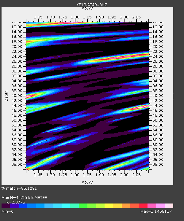
| Estimated Moho Depth: |
44.25 km |
| Estimated Crust Vp/Vs: |
2.08 |
| Assumed Crust Vp: |
6.159 km/s |
| Estimated Crust Vs: |
2.964 km/s |
| Estimated Crust Poisson's Ratio: |
0.35 |
|
| Radial Match: |
85.1091 % |
| Radial Bump: |
400 |
| Transverse Match: |
65.8612 % |
| Transverse Bump: |
400 |
| SOD ConfigId: |
3390531 |
| Insert Time: |
2019-04-10 18:31:18.633 +0000 |
| GWidth: |
2.5 |
| Max Bumps: |
400 |
| Tol: |
0.001 |
|

Signal To Noise
| Channel | StoN | STA | LTA |
| YB:AT49: :BHZ:20140319T12:30:37.519014Z | 11.627933 | 8.721247E-7 | 7.500256E-8 |
| YB:AT49: :BHN:20140319T12:30:37.519014Z | 3.4052114 | 2.332225E-7 | 6.848987E-8 |
| YB:AT49: :BHE:20140319T12:30:37.519014Z | 3.1663558 | 2.698242E-7 | 8.521601E-8 |
| Arrivals |
| Ps | 7.9 SECOND |
| PpPs | 22 SECOND |
| PsPs/PpSs | 30 SECOND |


