You are here: Home > Network List > YB13 - Continental Dynamics/Cent. Anatolian Tectonics:Surface to Mantle Dynamics During Stations List
> Station AT49 Kolukisa,Konya,Turkey > Earthquake Result Viewer
AT49 Kolukisa,Konya,Turkey - Earthquake Result Viewer
| Earthquake location: |
Iceland |
| Earthquake latitude/longitude: |
64.5/-17.7 |
| Earthquake time(UTC): |
2014/08/27 (239) 00:16:29 GMT |
| Earthquake Depth: |
3.7 km |
| Earthquake Magnitude: |
5.3 Mww, 5.2 mb |
| Earthquake Catalog/Contributor: |
ISC/ISC |
|
| Network: |
YB Continental Dynamics/Cent. Anatolian Tectonics:Surface to Mantle Dynamics During |
| Station: |
AT49 Kolukisa,Konya,Turkey |
| Lat/Lon: |
38.51 N/32.25 E |
| Elevation: |
1036 m |
|
| Distance: |
39.0 deg |
| Az: |
107.269 deg |
| Baz: |
328.247 deg |
| Ray Param: |
0.07526045 |
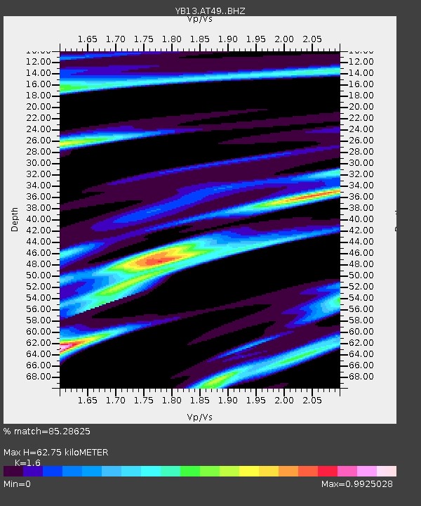
| Estimated Moho Depth: |
62.75 km |
| Estimated Crust Vp/Vs: |
1.60 |
| Assumed Crust Vp: |
6.159 km/s |
| Estimated Crust Vs: |
3.849 km/s |
| Estimated Crust Poisson's Ratio: |
0.18 |
|
| Radial Match: |
85.28625 % |
| Radial Bump: |
302 |
| Transverse Match: |
73.78328 % |
| Transverse Bump: |
400 |
| SOD ConfigId: |
3390531 |
| Insert Time: |
2019-04-13 15:26:09.584 +0000 |
| GWidth: |
2.5 |
| Max Bumps: |
400 |
| Tol: |
0.001 |
|

Signal To Noise
| Channel | StoN | STA | LTA |
| YB:AT49: :BHZ:20140827T00:23:25.70001Z | 10.555522 | 4.543567E-7 | 4.3044455E-8 |
| YB:AT49: :BHN:20140827T00:23:25.70001Z | 3.489349 | 1.1395666E-7 | 3.265843E-8 |
| YB:AT49: :BHE:20140827T00:23:25.70001Z | 6.5555215 | 2.0336665E-7 | 3.1022193E-8 |
| Arrivals |
| Ps | 6.6 SECOND |
| PpPs | 25 SECOND |
| PsPs/PpSs | 31 SECOND |


