You are here: Home > Network List > YB13 - Continental Dynamics/Cent. Anatolian Tectonics:Surface to Mantle Dynamics During Stations List
> Station AT49 Kolukisa,Konya,Turkey > Earthquake Result Viewer
AT49 Kolukisa,Konya,Turkey - Earthquake Result Viewer
| Earthquake location: |
Shikoku, Japan |
| Earthquake latitude/longitude: |
32.1/132.1 |
| Earthquake time(UTC): |
2014/08/28 (240) 19:14:35 GMT |
| Earthquake Depth: |
22 km |
| Earthquake Magnitude: |
5.8 MWB |
| Earthquake Catalog/Contributor: |
NEIC PDE/NEIC COMCAT |
|
| Network: |
YB Continental Dynamics/Cent. Anatolian Tectonics:Surface to Mantle Dynamics During |
| Station: |
AT49 Kolukisa,Konya,Turkey |
| Lat/Lon: |
38.51 N/32.25 E |
| Elevation: |
1036 m |
|
| Distance: |
77.6 deg |
| Az: |
307.697 deg |
| Baz: |
58.884 deg |
| Ray Param: |
0.050158486 |
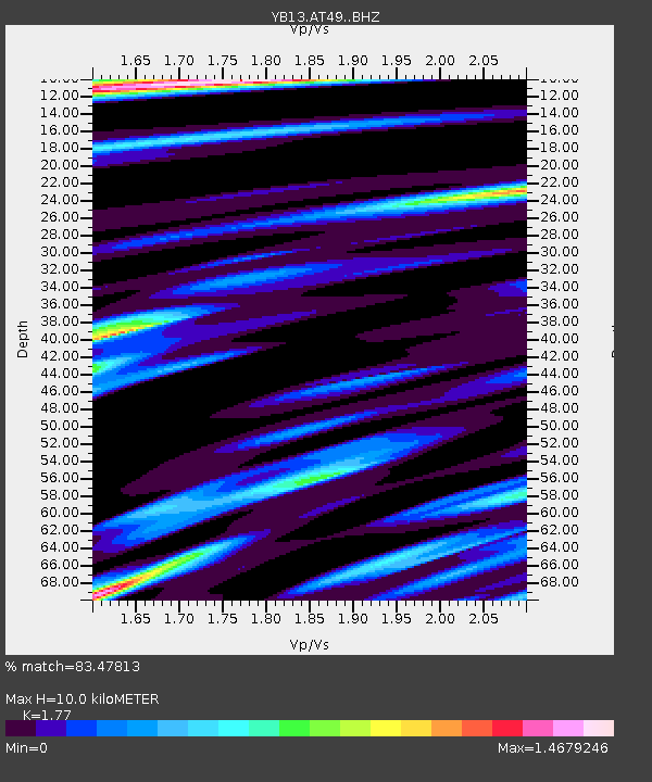
| Estimated Moho Depth: |
10.0 km |
| Estimated Crust Vp/Vs: |
1.77 |
| Assumed Crust Vp: |
6.159 km/s |
| Estimated Crust Vs: |
3.479 km/s |
| Estimated Crust Poisson's Ratio: |
0.27 |
|
| Radial Match: |
83.47813 % |
| Radial Bump: |
400 |
| Transverse Match: |
85.30871 % |
| Transverse Bump: |
400 |
| SOD ConfigId: |
3390531 |
| Insert Time: |
2019-04-13 16:47:57.241 +0000 |
| GWidth: |
2.5 |
| Max Bumps: |
400 |
| Tol: |
0.001 |
|

Signal To Noise
| Channel | StoN | STA | LTA |
| YB:AT49: :BHZ:20140828T19:25:59.040022Z | 15.499934 | 6.088756E-7 | 3.9282465E-8 |
| YB:AT49: :BHN:20140828T19:25:59.040022Z | 2.557308 | 1.190744E-7 | 4.6562405E-8 |
| YB:AT49: :BHE:20140828T19:25:59.040022Z | 4.4199514 | 1.9375334E-7 | 4.383608E-8 |
| Arrivals |
| Ps | 1.3 SECOND |
| PpPs | 4.4 SECOND |
| PsPs/PpSs | 5.7 SECOND |


